On September 30, 2024, SAPAA Field Trip partricipants conducted an inspection at Lloyd Creek Natural Area. The rolling terrain supports aspen forest with a diverse understory giving the Natural Area a high naturalness score (3/4). Invasives are confined to the trails, created and still used by ATV riders. Recommendations are for weed control and improved signage.
The field trip was composed of two teams: North- and South-Bound. North- Bound (Patsy, Manna, and Susan) headed North from RR 31. Phrank (the sole member of the South team!) parked at the terminus of the same RR except on the opposite side of the NA and he headed South. The two groups met up in the middle and car pooled back to the vehicles.
Perspectives of a Diverse Team
The detailed inspection reports are provided below. The ladies are all botanists and they noted invasive species along the tracks but diminishing into the surrounding forests.
All team members noted the prevalence of OHV (e.g. quad or ATV) tracks. These are always a Faustian bargain of giving access while allowing for invasive species colonization and severe erosion. All team members agree on a Naturalness score of 3/4 for the site.
Inspection Report
Inspection Report: 2024-09-30: Lloyd Creek (NA); Susan N
| Question | Q## | Response |
| General Information | ||
| Date/Site/Submitter: | Q21/22/12 | 2024-09-30: Lloyd Creek (NA); Susan N |
| Guest Names | Q14 | Susan Neuman |
| SAPAA Member | Q16 | No |
| Over all Impression of the Site | ||
| What is the Naturalness of the Site? 4=Great, 0=Terrible | Q31 | 3 |
| How Natural?: comments | Q32 | We walked into the natural area on a wide vehicle track. There were a number of invasive plant species along and beside the track. Away from it, however, the invasive species diminished and the vegetation appeared native. We heard very few birds and saw no wildlife on the ground. |
| How was your visit to the PA? | ||
| Trip Duration | Q41 | half a day (e.g. about 4 hours) |
| Why Did you Go? | Q42 | Visit nature, Plant identification, PA Site inspection for SAPAA |
| Visit Details | Q43 | We entered the natural area close to the intersection of Township Rd 460 and Range Rd 31. We then followed a wide OHV track in a northerly direction, and then a narrow animal track, eventually exiting the NA at the intersection of highway 13 and Range Rd 31. Total distance walked was approximately 2.5 km. |
| What is in the Site? | ||
| Ease to Visit | Q51 | None of the Above |
| Biological Observations | Q52 | There was no signage to indicate the natural area in the spot where we entered. There was a sign, however, on the track as we were leaving the natural area. We found many forest species of native plants, as well as many invasive weeds (thistles, smooth brome, dandelions, clover). We found one specimen of a rare (S3) native plant – Lactuca biennis. (We uploaded our observation to iNaturalist.) |
| Submissions to iNaturalist | Q53 | Yes |
| Geological Observations | Q54 | |
| Designation as a Protected Area | Q55 | Signage, Fencing |
| Comments | Q56 | The fencing appears to belong to the neighbouring properties, rather than being erected to protect the natural area. As a consequence, OHVs have made a number of tracks in the area that we visited, some with ruts so deep that a second track had to be created to get around the muddy spots. |
| Human Activities/Disturbances | ||
| Agricultural Activities | Q61 | None noted |
| Resource extraction | Q62 | None Noted |
| Motorized disturbances (ATV or vehicle activity). | Q63 | Off Highway Vehicles (e.g. quads, motorbikes), 4×4 vehicles |
| Animal or self propelled activities | Q64 | None Noted |
| Gathering and Dumping Activities | Q65 | None Noted |
| Infrastructure encroachment | Q66 | None Noted |
| Comments | Q67 | |
| What Needs to be Done? | ||
| Remediation/Protection Activities Needed | Q71 | Fencing, Invasive Weed Removal, Signs |
| What Have you Done Recently to Help the site? | Q72 | Visit and Submitted This Report! |
| Nearby Stewards? | Q73 | |
| Comments | Q74 | |
| Last Words | Q82 | Photos are available from Susan’s iNaturalist account. |
Inspection Report: 2024-09-30: Lloyd Creek (NA); Patsy C.
| Question | Q## | Response |
| General Information | ||
| Date/Site/Submitter: | Q21/22/12 | 2024-09-30: Lloyd Creek (NA); Patsy C. |
| Guest Names | Q14 | |
| SAPAA Member | Q16 | Yes |
| Over all Impression of the Site | ||
| What is the Naturalness of the Site? 4=Great, 0=Terrible | Q31 | 3 |
| How Natural?: comments | Q32 | There is some ingression of a non-native grass (orchard grass) along the trail from the south for a considerable distance, the result of agricultural contamination, perhaps being brought in by ATVs. In some of the lower-lying areas ATV use had created deep ruts necessitating braiding. Riparian weeds were often associated with these ruts. However, overall the trail, although weedy, was in good shape and the weeds had not penetrated into the forest cover. The forest and associated depressional areas was diverse and undisturbed. |
| How was your visit to the PA? | ||
| Trip Duration | Q41 | half a day (e.g. about 4 hours) |
| Why Did you Go? | Q42 | Visit nature, Plant identification, PA Site inspection for SAPAA |
| Visit Details | Q43 | Natural plant communities, largely unspoilt. The terrain was easier than I expected. We walked in an approximate straight line from TWP Rd 460 to the gravel road leading to Hwy 13, in line approx. with RR 31, a distance of just under 3 km south to north, walking for approx. 4 hours. |
| What is in the Site? | ||
| Ease to Visit | Q51 | Entrance signs, information, etc. |
| Biological Observations | Q52 | Access was relatively straightforward from RR31, using an ATV track from the western extent of Twp Road 460, and from the north an extension of the gravel road RR31 from Hwy 13. Following this track uphill leads to the NA boundary which is posted by sign. (No sign at the south access.) The terrain is rolling, and forested in both the uplands and the depressional areas. The predominant tree cover was aspen and balsam poplar with scattered individuals and pockets of white spruce; Alaskan birch and some river alder were present in the lower-lying areas between the slopes. Beaked hazelnut was dominant on the well-drained slopes; elsewhere the shrub cover was very varied. Floral elements indicative of a western location were present. Over 100 species of vascular plant were recorded. Non-native species are mainly confined to the trails. |
| Submissions to iNaturalist | Q53 | Yes |
| Geological Observations | Q54 | Soil is likely a loam. Adjacent farming is mainly cattle grazing. |
| Designation as a Protected Area | Q55 | Signage, Other (see comments) |
| Comments | Q56 | Previously researched for website, and on-the-ground reconnoitering visit by Frank. Google Earth was consulted for further details and access. |
| Human Activities/Disturbances | ||
| Agricultural Activities | Q61 | None noted |
| Resource extraction | Q62 | None Noted |
| Motorized disturbances (ATV or vehicle activity). | Q63 | Off Highway Vehicles (e.g. quads, motorbikes) |
| Animal or self propelled activities | Q64 | None Noted |
| Gathering and Dumping Activities | Q65 | None Noted |
| Infrastructure encroachment | Q66 | None Noted |
| Comments | Q67 | |
| What Needs to be Done? | ||
| Remediation/Protection Activities Needed | Q71 | Invasive Weed Removal, Signs |
| What Have you Done Recently to Help the site? | Q72 | Visit and Submitted This Report! |
| Nearby Stewards? | Q73 | |
| Comments | Q74 | Some control of non-native orchard grass (Dactylis glomerata) which has invades the trail for considerable distances could be carried out. An increase in ATV usage or pedestrian traffic could result in more weeds along the trail. Currently, the site provides a good example of an almost pristine mature mixedwood forest, with typical, varied understory, and the presence of some western species indicative of the site’s location. |
| Last Words | Q82 | Want to visit again in another season! |
Inspection Report: 2024-09-30: Lloyd Creek (NA); Phrank P.
| Question | Q## | Response |
| General Information | ||
| Date/Site/Submitter: | Q21/22/12 | 2024-09-30: Lloyd Creek (NA); Phrank P. |
| Guest Names | Q14 | |
| SAPAA Member | Q16 | Yes |
| Over all Impression of the Site | ||
| What is the Naturalness of the Site? 4=Great, 0=Terrible | Q31 | 3 |
| How Natural?: comments | Q32 | There are several braided ATV trails. Wet depressions create gouged trails and the usual muddy disturbances. Past and more recent trail clearance (e.g. cutting deadfalls) are evident. |
| How was your visit to the PA? | ||
| Trip Duration | Q41 | half a day (e.g. about 4 hours) |
| Why Did you Go? | Q42 | Other (see comments) |
| Visit Details | Q43 | Field Research, see: https://yegville.ca/4-part-yegville/sw-yegville/lloyd-creek-na/ |
| What is in the Site? | ||
| Ease to Visit | Q51 | No Amenities, No Signage |
| Biological Observations | Q52 | Access is challenging and involves steep climbs, wet areas, and occasional cow herd (see the image gallery). Access to the Eastern Portion of the site is primarily from the South via TWP 460, or from the North via the terminus of RR 13. The Western portion is not yet explored and is surrounded by private land. Paid heed to the multiple “no trespassing” signs. Scats and tracks suggest ungulates such as moose enjoy the site. The route taken included a slight transit through the adjoining Crown Land adjoining East Twin Lake. This land is under a Tourism and Commercial Development Lease to the County of Wetaskiwin. |
| Submissions to iNaturalist | Q53 | No, did not see anything of note |
| Geological Observations | Q54 | Numerous depressions with corresponding wet areas. Topography is surprisingly rolling. |
| Designation as a Protected Area | Q55 | Signage, Fencing, Exists but in disrepair |
| Comments | Q56 | Fencing on the Eastern border of the North Quarter is in disrepair. |
| Human Activities/Disturbances | ||
| Agricultural Activities | Q61 | None noted |
| Resource extraction | Q62 | None Noted |
| Motorized disturbances (ATV or vehicle activity). | Q63 | Off Highway Vehicles (e.g. quads, motorbikes) |
| Animal or self propelled activities | Q64 | Hiking Trails, Botanical pursuits (e.g. plant identification) |
| Gathering and Dumping Activities | Q65 | None Noted |
| Infrastructure encroachment | Q66 | Roads |
| Comments | Q67 | As RR 13 heads South, the degree of excavation suggests it might have been a service road for logging, etc. This route has historically seen ATV traffic although little recently based on the September 2024 visit. A wet area and then a steep climb has further discouraged additional ATV traffic. Along the East border of the North Quarter, fencing is showing its age and in some cases is down. |
| What Needs to be Done? | ||
| Remediation/Protection Activities Needed | Q71 | Fencing, Signs |
| What Have you Done Recently to Help the site? | Q72 | Visit and Submitted This Report! |
| Nearby Stewards? | Q73 | |
| Comments | Q74 | |
| Last Words | Q82 | Only a small portion of the site was explored – worth a return visit! |
Images from Inspection
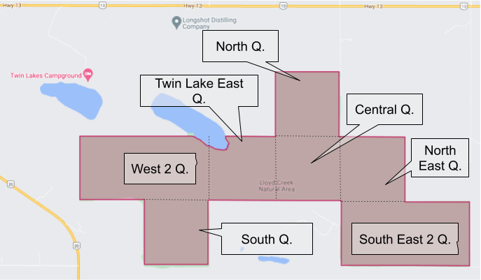
Naming conventions for the Lloyd Creek Quarter Sections. 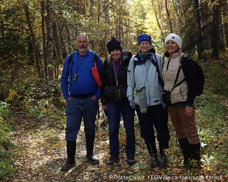
L-R, Frank, Patsy, Susan, and Manna, Lloyd Creek NA, 2024-09-30, P. Potter. 
Patsy and Manna examining the damage from ATVs going through a wet area, Lloyd Creek NA, 2024-09-30, P. Potter. 
Susan from ENPC examining interesting flora as we work our way back N to RR 133, Lloyd Creek NA, 2024-09-30, P. Potter. 
Looking S toward TWP 460, land beyond this point is private and posted no trespassing, Lloyd Creek NA, 2024-09-30, P. Potter. 
Looking S across the valley where TWP 460 runs at a single-track trail, likely originally a game trail broadened by human use, Lloyd Creek NA, 2024-09-30, P. Potter 
Looking E along the N border of the site at a flood ATV track with braiding occurring, Lloyd Creek NA, 2024-09-30, P. Potter. 
Looking N at the embankment suggesting that RR13 may have served as a road at one time, Lloyd Creek NA, 2024-09-30, P. Potter. 
Looking N after the steep climb, Lloyd Creek NA, 2024-09-30, P. Potter. 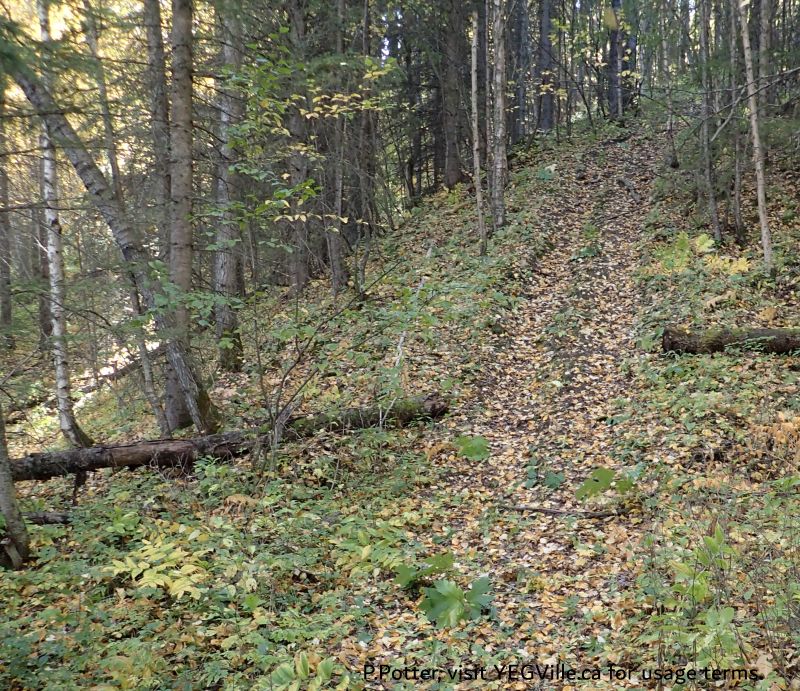
Looking S and a steep climb just as RR 13 enters the site, Lloyd Creek NA, 2024-09-30, P. Potter. 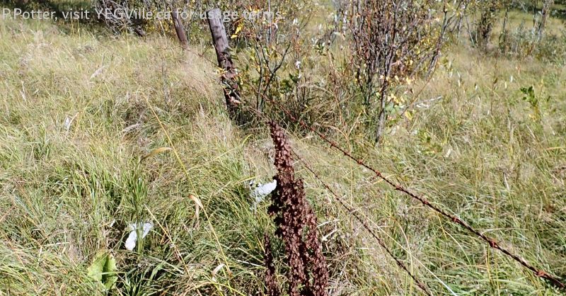
Looking S along RR 13, fence is showing its age as it crosses a wet depression, Lloyd Creek NA, 2024-09-30, P. Potter. 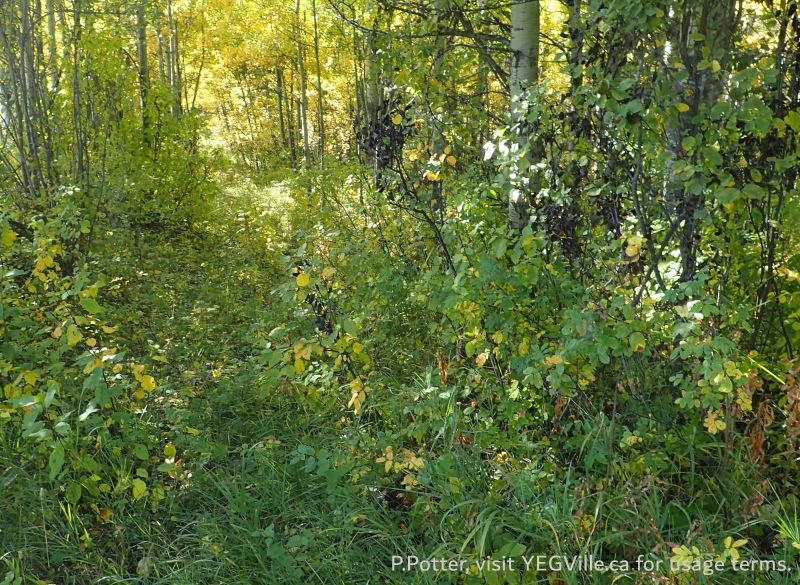
Looking S along RR 13 flora relatively undisturbed, Lloyd Creek NA, 2024-09-30, P. Potter. 
Looking S along RR 13 and at a boundary sign at the NE corner of the site, Lloyd Creek NA, 2024-09-30, P. Potter. 
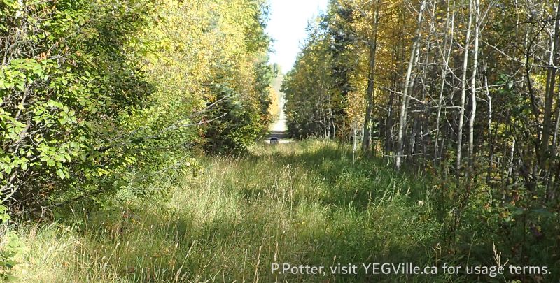
Looking N into the site from TWP 460 at the SE corner at an ATV track, Lloyd Creek NA, 2024-09-30, P. Potter. Looking North along RR 13, HWY 13 is in the distance, Lloyd Creek NA, 2024-09-30, P. Potter. 


