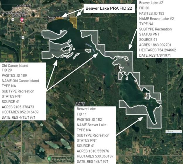
The northern shore of Beaver Lake is located about 5 km southeast of Lac la Biche. The lake has three (PNT) Natural Areas and one PRA along its shores.
- Map of the Area
- Biophysical Observations (via iNaturalist)
- Other Information
- Site Statistics
- References
- Further Reading
Map of the Area
Any maps and map views are for general information only. Do not rely on them for navigation or to determine legal boundaries.
Biophysical Observations (via iNaturalist)
Are you a member of iNaturalist.ca? It is free to join and you can help nature by making observations with your smart phone.
If there are no or only a few observations, how about visiting and adding some? While there, complete a site inspection report (but read the Site Inspections terms and conditions first).
Observations & Projects for this Natural Area
- Beaver Lake (PNT) Observations.
- Beaver Lake #2 (PNT) Observations.
- Old Canoe Island (PNT) Observations.
- No iNaturalist Projects.
Other Information
Three PNTs and One PRA. Much of the lake shore is protected by three PNTs. The Beaver Lake First Nation (131) occupies a large section of the south shore of the lake. Beaver Lake PRA occupies two non-contiguous sites on the north shore [1].
Headwaters and History. The lake is the headwaters of the Beaver River and both have appeared on maps dating back to 1790. These are traditional lands for the Woodland Cree who were assigned reserve 131 under Treaty 6 [2].
Inflows, Outflows and Churchill. Nearby lakes and streams drain into the lake including Elinor, Lac la Croix, Roseland, and Normandeau Lakes, although some of these are intermittent. The outlet is on the west side of the lake. Despite the Beaver River’s proximity to Edmonton, it empties into the Churchill River as opposed to the North Saskatchewan (which flows to the south) or the Athabasca (which flows north of the Beaver River) [2, 3].

Site Statistics
| Site Name | Beaver Lake (PNT) |
| Site Type | Natural Area |
| Subtype | Protective Notation (PNT) |
| Natural Region(s) | Central Mixedwood |
| O.C. No. (Land Ref. Manual) | N/A |
| PASite ID (Map Ref #) | 182 |
| Site # (Parks Website) | N/A |
| Total Area | 530.36 ha. (1310.56 ac.) |
| Steward-Status | |
| Recreation Activities | |
| IUCN | |
| Operated By | |
| Notes and Comments |
| Site Name | Beaver Lake #2 (PNT) |
| Site Type | Natural Area |
| Subtype | Protective Notation (PNT) |
| Natural Region(s) | Central Mixedwood |
| O.C. No. (Land Ref. Manual) | N/A |
| PASite ID (Map Ref #) | 183 |
| Site # (Parks Website) | N/A |
| Total Area | 754.29 ha. (1863.90 ac.) |
| Steward-Status | |
| Recreation Activities | |
| IUCN | |
| Operated By | |
| Notes and Comments |
| Site Name | Old Canoe Island (PNT) |
| Site Type | Natural Area |
| Subtype | Protective Notation (PNT) |
| Natural Region(s) | Central Mixedwood; Dry Mixedwood |
| O.C. No. (Land Ref. Manual) | N/A |
| PASite ID (Map Ref #) | 189 |
| Site # (Parks Website) | N/A |
| Total Area | 852.02 ha. (2105.38 ac.) |
| Steward-Status | |
| Recreation Activities | |
| IUCN | |
| Operated By | |
| Notes and Comments |
References
The following links are provided as a courtesy but are not verified or endorsed by SAPAA. Clicking on the link will cause you to leave the SAPAA website. Primary source of information is the Government of Alberta (All links accessed on 2026-01-06).
- Lac La Biche County, Ownership Maps, South Sheet.
- Mitchell, Patricia, and E. E. Prepas. “Atlas of Alberta Lakes.” Edmonton, Alberta, University of Alberta Press, 1990, pp. 232-234.
- Wikipedia, Beaver River.
