Protected Areas East of Westlock and northeast of the village of Clyde, the Bridge Lake Natural Area (NA) complex is one of a number of protected sites within this rich farming region. The OC and PNT areas are contiguous on the west side of the lake but separated by a TWP.

- Map of the Area
- Other Information
- Biophysical Observations (via iNaturalist.ca)
- Site Statistics
- References
- Site Inspection Reports
- Further Reading
Map of the Area
Any maps and map views are for general information only. Do not rely on them for navigation or to determine legal boundaries.
Other Information
This Natural Area complex totaling about 280 ha contains vegetated sandhills adjacent to Bridge Lake with forest vegetation of jack pine and aspen, and willow/sedge meadows associated with the lakeshore and a small creek. The lake is an important waterfowl production area (Alberta Parks website, 2012).
During the drought years of the 21st century the shoreline of the lake receded and there was an extensive infestation of the weed common tansy. In the summer of 2021, following high precipitation in 2020, the water level was within 100 metres of the road, and bands of drowned willows and trees remained in the lake several metres from shore. There was no sign of tansy. (Personal observation: PCotterill).
Biophysical Observations (via iNaturalist.ca)
Are you a member of iNaturalist.ca? It is free to join and you can help nature by making observations with your smart phone.
If there are no or only a few observations, how about visiting and adding some? While there, complete a site inspection report (but read the Site Inspections terms and conditions first).
Observations & Projects for this Natural Area
- Bridge Lake (OC) Observations.
- Bridge Lake (PNT) Observations.
- No iNaturalist Projects.
Site Statistics
Bridge Lake (OC)
| Site Name | Bridge Lake |
| Site Type | Natural Area |
| Subtype | Order-in-council (OC) |
| Natural Region(s) | Dry Mixedwood |
| O.C. No. (Land Ref. Manual) | 519/95 |
| PASite ID (Map Ref #) | 48 |
| Site # (Parks Website) | 478 |
| Total Area | 109.77 ha. (271.24 ac.) |
| Steward-Status | |
| Recreation Activities | none noted |
| IUCN | II |
| Operated By | Parks Division |
| Notes and Comments |
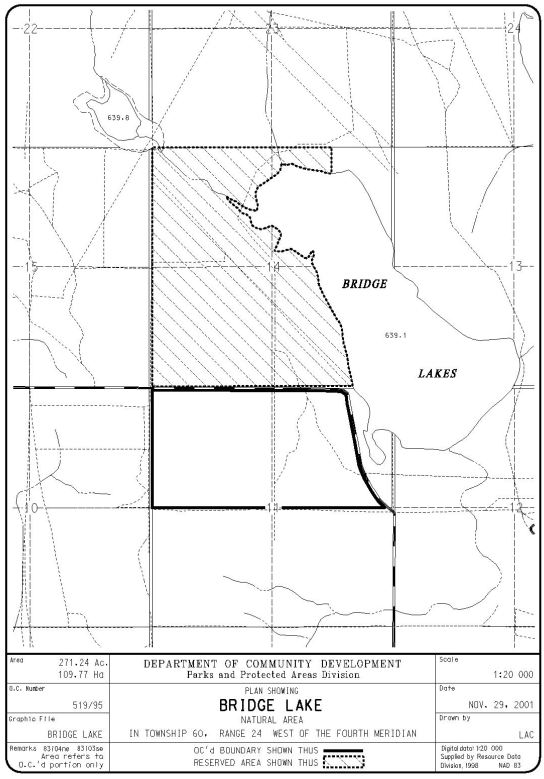
Bridge Lake (PNT)
| Site Name | Bridge Lake (PNT) |
| Site Type | Natural Area |
| Subtype | Protective Notation (PNT) |
| Natural Region(s) | Dry Mixedwood |
| O.C. No. (Land Ref. Manual) | N/A |
| PASite ID (Map Ref #) | 48 |
| Site # (Parks Website) | N/A |
| Total Area | 170 ha. (420 ac.) |
| Steward-Status | |
| Recreation Activities | |
| IUCN | IV*6 |
| Operated By | |
| Notes and Comments |
References
The following links are provided as a courtesy but are not verified or endorsed by SAPAA. Clicking on the link will cause you to leave the SAPAA website. Primary source of information is: Government of Alberta –Information & Facilities – Bridge Lake Natural Area | Alberta Parks (2022-02-12).
Site Inspection Reports
Further Reading

Looking north along the equivalent of RR 242, western border of Bridge Lake NA, P. Potter, October 1, 2023. 
Looking south towards the southwest corner of the Bridge Lake NA, P. Potter, October 1, 2023. 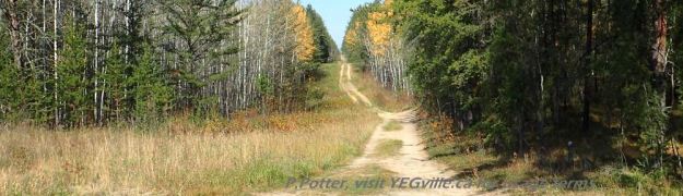
ATV track heading north from the oil field installation, Bridge Lake NA, P. Potter, October 1, 2023. 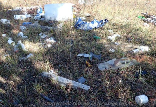
Dumping on the north east corner of Bridge Lake NA, P. Potter, October 1, 2023. 
Oil field installation, north east corner of Bridge Lake NA, P. Potter, October 1, 2023.
