About 7 km west of Caroline on Highway 22, this Natural Area protects the steep banks of the Clearwater River in Central Alberta.
- Map of the Area
- Other Information
- Biophysical Observations (via iNaturalist.ca)
- Site Statistics
- References
- Further Reading

Map of the Area
Any maps and map views are for general information only. Do not rely on them for navigation or to determine legal boundaries.
Other Information
This site is located adjacent to the Clearwater River with steep banks forested mainly with aspen, balsam poplar and some white spruce. It is in the Lower Foothills Natural Subregion of the Foothills Natural Region.
What’s in a Name – Clearwater? This NA has two interesting name attributes. Firstly, exactly which Clearwater River are we talking about? Alberta has two rivers with this name, a northern one, and the one that relates to this site. The Clearwater River to the southwest of this NA is located entirely within Alberta but discharges into the North Saskatchewan River near Rocky Mountain House [1]. This westerly Clearwater shares its name with a mountain, a lake and a pass, and has been in use since at least 1814 [2].
The other, northern Clearwater, a Canadian Heritage River, arises in Saskatchewan and was named for the contrast in water colour between it and the grey, glacial Athabasca River to which it discharges in Fort McMurray [3]. Before being named the Clearwater, the northern river was known as the Pelican River and the Lesser Athabasca River [2].
What’s in a Name – Ricinus? If having two rivers of the same name is not confusing enough, how about the puzzle of having a locality named after a plant species, the castor-oil plant belonging to the genus Ricinus, which is not native to Alberta [4]? Likely the NA was named for the locality of Ricinus on the Clearwater River, but why was the locality so named? Unfortunately, the answer is not readily available and will need to remain a mystery – for now.
Raven River flows south of the Clearwater and comes within about 1 km of this NA. Unlike the Clearwater, the Raven empties into the Red Deer watershed whose waters also join the North Saskatchewan in due course.

Biophysical Observations (via iNaturalist.ca)
Are you a member of iNaturalist.ca? It is free to join and you can help nature by making observations with your smart phone.
If there are no or only a few observations, how about visiting and adding some? While there, complete a site inspection report (but read the Site Inspections terms and conditions first).
Observations & Projects for this Natural Area
- Observations for this Natural Area.
- No iNaturalist Projects.
Site Statistics
| Site Name | Clearwater Ricinus |
| Site Type | Natural Area |
| Subtype | Order-in-council (OC) |
| Natural Region(s) | Lower Foothills |
| O.C. No. (Land Ref. Manual) | 454/71 |
| PASite ID (Map Ref #) | 134 |
| Site # (Parks Website) | 532 |
| Total Area | 83.88 ha. (207.27 ac.) |
| Steward-Status | |
| Recreation Activities | none noted |
| IUCN | II |
| Operated By | Parks Division |
| Notes and Comments |

References
The following links are provided as a courtesy but are not verified or endorsed by SAPAA. Clicking on the link will cause you to leave the SAPAA website. Primary source of information is Information & Facilities – Clearwater Ricinus Natural Area | Alberta Parks (All links accessed on 2023-01-05).
- Wikipedia – Clearwater River (Alberta).
- Aubrey, Merrily K., ed. Concise Place Names of Alberta. Calgary: University of Calgary Press, 2006, p. 69.
- Wikipedia – Clearwater River (Saskatchewan).
- Peel 5240: Geographic Board of Canada, Place-names of Alberta (1928) (ualberta.ca).
Further Reading
- Bamboorods, P. Anderson, Watching Stauffer Creek Die
- Merriam-Webster Medical Terms, Ricinus
- Wikipedia, List of Rivers of Alberta

Clearwater Ricinus NA 2004-04-04 (TBlake) -View West 
Clearwater Ricinus NA 2004-04-04 (TBlake) – View South 
Clearwater Ricinus NA 2003-06-25 (TBlake) – View West 
Clearwater Ricinus NA 2003-06-25 (TBlake) – View South 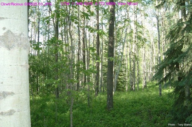
Clearwater Ricinus NA 2003-06-25 (TBlake) – View North East 
Clearwater Ricinus NA 2003-06-25 (TBlake) – View North 
Clearwater Ricinus NA 2004-04-04 (TBlake)
