This is one of three areas making up ‘the Ghost’. This site adjoins the Don Getty Wildland Provincial Park and Banff National Park.
- Map of the Area
- Other Information
- Biophysical Observations (via iNaturalist.ca)
- Site Statistics
- References
- Further Reading
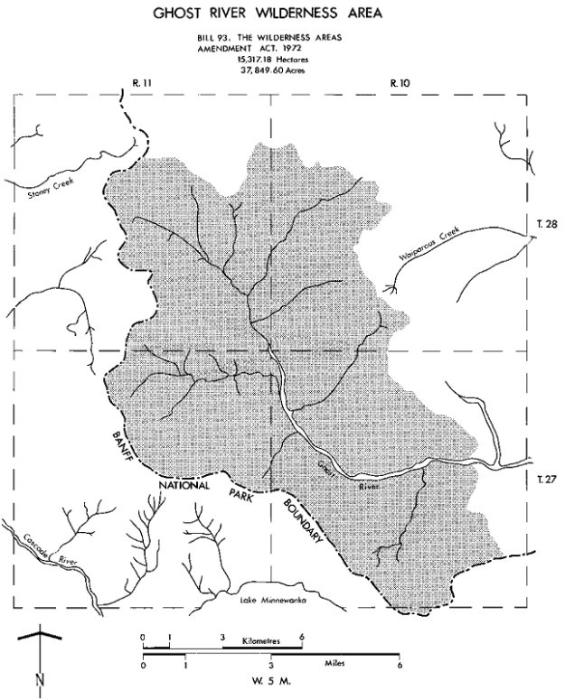
Map of the Area
Any maps and map views are for general information only. Do not rely on them for navigation or to determine legal boundaries.
Other Information
Ghost River Wilderness Area consists of rugged mountain terrain and glacier-carved valleys. Aylmer, Apparition, Oliver and Costigan Mountains reach elevations of 2743 to 3353 m. Below 2100 m there are subalpine forests of Engelmann spruce, white spruce, subalpine fir and lodgepole pine; above 2100 m the vegetation consists of flowering plants including grasses and sedges. Several rare species of butterflies are found in the area. Wildlife includes Rocky Mountain Bighorn Sheep, deer, Moose, Cougar, bears and wolves. Hunting and fishing are prohibited.
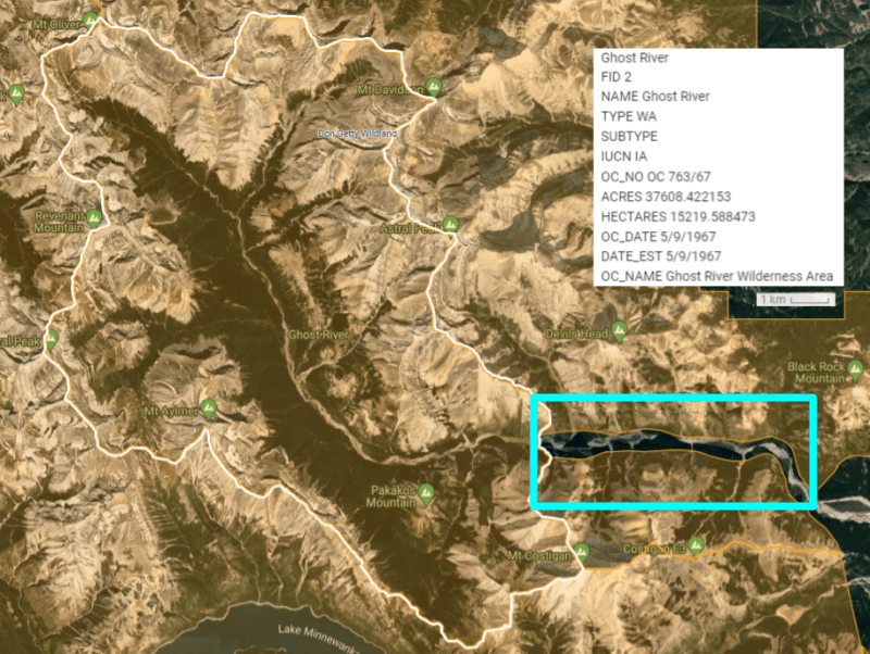
1932, 1961, Today. Ghost River was one of the first eight provincial parks established in 1932 [1]. It was upgraded to a Wilderness Area in 1961 [2]. Today, the WA is nearly surrounded by Protected Areas on all four sides save for a narrow corridor on the Ghost River (see graphic below).
Rich with History. The first recorded visit was by Sir George Simpson, the governor of Hudson’s Bay Company, but the name “Ghost” wasn’t used to describe the area until Dr. James Hector, a surgeon, arrived with the Palliser Expedition. The name was in reference to a Stoney legend that talked of ghosts patrolling the riverbank searching for the skulls of defeated warriors after doing battle with the Cree. The skulls were then placed on the steep walls of nearby Devil’s Head Mountain to appease its spirit. Large flat-topped mountains, such as Devil’s Head, were believed to be inhabited by spirits and carried a high degree of respect within many First Nation communities, so regular offerings to the mountain were necessary. Due to its visibility and unique protruding peak, Devil’s Head was also a useful signpost. First Nations and Europeans alike used these highly visible mountains as a means of navigation. Additional stories also exist that place numerous First Nation grave-sites along the banks of the Ghost River and Dr. Hector even mentions that the forest atop Deadman Hill, located between the Ghost and Bow Rivers, is actually one big burial ground.[3]
Nearby Heavy Use and Rampant Illegal Behaviour. Northeast of Ghost’s protected areas is the Ghost-Waiparous Public Land Use Zone (PLUZ) which provides the provincial government with the ability to control unplanned motorized access and lawless behaviour. Unfortunately, heavy use and rampant illegal behaviour has led to severe degradation of the area’s ecosystems and significant reduction in suitable wildlife habitat. In the 2014 South Saskatchewan Regional Plan, the provincial government committed to undertaking a sub-regional planning initiative to better manage linear disturbance within the area. Currently, many of the popular OHV trails – both designated and illegal – run along industrial seismic lines and cut lines, leading to the unforeseen, unregulated, and largely immeasurable degradation of the area’s sensitive habitats.[4]
Biophysical Observations (via iNaturalist.ca)
Are you a member of iNaturalist.ca? It is free to join and you can help nature by making observations with your smart phone.
If there are no or only a few observations, how about visiting and adding some? While there, complete a site inspection report (but read the Site Inspections terms and conditions first).
Observations & Projects for this Natural Area
- Observations for this Natural Area.
- No iNaturalist Projects.
Site Statistics
| Site Name | Ghost River |
| Site Type | WA |
| Subtype | Order-in-council (OC) |
| Natural Region(s) | Alpine; Subalpine |
| O.C. No. (Land Ref. Manual) | NA |
| PASite ID (Map Ref #) | 1101 |
| Site # (Parks Website) | 396 |
| Total Area | 15317.18 ha. (37848.75 ac.) |
| Steward-Status | |
| Recreation Activities | Camping – backcountry, Hiking – backcountry |
| IUCN | IB |
| Operated By | Parks Division |
| Notes and Comments |
References
The following links are provided as a courtesy but are not verified or endorsed by SAPAA. Clicking on the link will cause you to leave the SAPAA website. Primary source of information is: Information & Facilities – Ghost River Wilderness Area | Alberta Parks (All links accessed on 2023-01-18).
- History of Natural Areas and Ecological Reserves 1977-1994, SAPAA Newsletter No. 41 January 2022 , p. 3.
- Wikipedia, Ghost River Wilderness Area.
- Calgary Guardian, Exploring in the Land of Ghosts .
- Alberta Wilderness Association, Areas of Concern: Ghost Areas
