Presumably the lake’s name is descriptive as it lies below two steep hills. The PNT is about 25 km northwest of the Town of Smoky Lake and is composed of two non-adjoined sites.
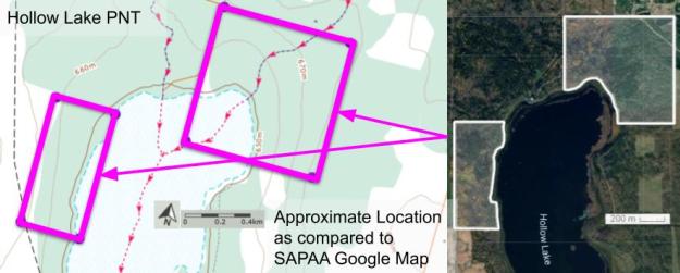
Map of the Area
Any maps and map views are for general information only. Do not rely on them for navigation or to determine legal boundaries.
Biophysical Observations (via iNaturalist)
Are you a member of iNaturalist.ca? It is free to join and you can help nature by making observations with your smart phone.
If there are no or only a few observations, how about visiting and adding some? While there, complete a site inspection report (but read the Site Inspections terms and conditions first).
Observations & Projects for this Natural Area
- Observations for this Natural Area.
- No iNaturalist Projects.
Other Information
Hollow seems to be an apt description of the lake, noting the 30-40 m elevation difference between the surrounding hills and the lake. The parcels of land between these two non-adjoined sites are private [1].
Site Statistics
| Site Name | Hollow Lake (PNT) |
| Site Type | Natural Area |
| Subtype | Protective Notation (PNT) |
| Natural Region(s) | Dry Mixedwood |
| O.C. No. (Land Ref. Manual) | N/A |
| PASite ID (Map Ref #) | 532 |
| Site # (Parks Website) | N/A |
| Total Area | 77.96 ha. (192.64 ac.) |
| Steward-Status | |
| Recreation Activities | |
| IUCN | |
| Operated By | |
| Notes and Comments |
References
The following links are provided as a courtesy but are not verified or endorsed by SAPAA. Clicking on the link will cause you to leave the SAPAA website. Primary source of information is the Government of Alberta – (All links accessed on 2026-02-19).
