Abutting the Canada-United States border, these two sites are adjoined and are located about 160 km southeast of Lethbridge.
- Map of the Area
- Other Information
- ER and NA Combined Notes
- Biophysical Observations (via iNaturalist.ca)
- Site Statistics
- References
- Further Reading
- Site Inspections
Map of the Area
Any maps and map views are for general information only. Do not rely on them for navigation or to determine legal boundaries.
Other Information
These two sites are adjoined. A portion of Onefour Heritage Rangeland NA is on the western border of the Kennedy Coulee ER.
ER and NA Combined Notes
Biodiversity Hotspot. AWA’s Milk River-Sage Creek Area of Concern is a biodiversity hotspot in the grasslands of southeastern Alberta. Its uplands, wetlands, and valleys constitute one of the largest undisturbed grasslands in Canada. This landscape is well-known for the unique geomorphology surrounding the Milk River, and the resulting biological communities that reside there; these include the northernmost range of the Short-horned Lizard and reintroduced populations of the Swift Fox. Crown land makes up the majority of the area with most of these lands given over to long-term grazing leases [1].
Prior to 1875, these sites were part of a much larger contiguous area supporting sizable populations of large mammals including the bison. Treaty #7 saw the First Nations relinquish their traditional lands and the lands were used for large ranching operations. Untouched by settlers, the sites remained under a grazing lease until 1978 and then were incorporated into the ER and NA in 1987 [2].
Kennedy Coulee
The ER contains rolling terrain and the Kennedy Creek valley. Springs and wetlands along the creek are ecologically rich environments that support several wildlife species, including Brown Thrasher, Black-billed Cuckoo, Grey Catbird, Golden Eagle, Ferruginous Hawk, Prairie Falcon, Bull Snake, Prairie Rattlesnake, Short-horned Lizard, Pronghorn Antelope, Mule Deer and Weidemeyer’s Admiral butterfly, a Canadian species-at-risk.
Plant communities are dominated by a variety of species, including blue grama, June and northern wheat grasses, lichens, deep-rooted shrubs, white and purple prairie-clovers, aspen and hybrid poplars, water birch, saskatoon, wild rose, and gooseberry. Access within the reserve is by foot only.
A Dry Gorge or Valley, the Kennedy Coulee is both in northern Montana and southern Alberta. Its exposed rocks of the Judith River Formation are a rich source of fossils. The coulee starts in Alberta and continues southeastwards for several miles into Hill County, Montana, before turning north and joining the Milk River valley near the US–Canadian border. The name “Kennedy’s Coulee” dates back at least to 1891, when a coal mine was under development there [3].
Political Hay in 1987. The year 1987 was the designated Year of Wildlife Conservation in Canada by provincial and territorial wildlife ministers and their agencies. In Alberta, Wildlife ’87: Gaining Momentum was spearheaded by Cam Finlay, a well-known Alberta naturalist. More than a dozen new Natural Areas and several Ecological Reserves were designated during this period including these two [4].
Milk River
This NA contains expanses of gently rolling grassland dissected by deeply-cut stream valleys, coulees and rugged badlands. Permanent streams, springs and oxbow lakes are found throughout the area. This array of habitats supports hundreds of species of native plants and animals, some of which are very rare in Canada. The site also contains many geological features, including one of only five igneous rock dykes known on the Canadian plains, as well as several fossil and archaeological sites.
Milk River Natural Area includes part of Milk River Canyon, the deepest canyon on the Canadian prairies. Its grasslands are some of the most diverse and least disturbed in the country.
Small, isolated populations of Short-Horned Lizards, the only lizard native to Alberta, are found along the coulee rim where grassland meets exposed bedrock. Sleeping beneath the sand at night and basking in the morning sun, this bizarre creature has adapted to life in the hot, dry environment of the area.
Access, Good and Bad News. Access requires permission from the grazing lease owner and roads are impassable after wet weather – the bad news. The good news is that this has helped to maintain relatively undisturbed conditions for the area [5].
Milk, Lewis, and Clark. The Milk River was named by Lewis and Clark in 1805 as the river had the colour of tea with milk [6]. The river is unique of all Canadian rivers in that it is the only one flowing into the Mississippi river basin [7].
Biophysical Observations (via iNaturalist.ca)
Are you a member of iNaturalist.ca? It is free to join and you can help nature by making observations with your smart phone.
If there are no or only a few observations, how about visiting and adding some? While there, complete a site inspection report (but read the Site Inspections terms and conditions first).
Observations & Projects for this Natural Area
- Kennedy Coulee (ER) Observations.
- Milk River (NA) Observations
- No iNaturalist Projects.
Site Statistics
| Site Name | Kennedy Coulee |
| Site Type | Ecological Reserve |
| Subtype | Order-in-council (OC) |
| Natural Region(s) | Dry Mixedgrass |
| O.C. No. (Land Ref. Manual) | 690/87 |
| PASite ID (Map Ref #) | 413 |
| Site # (Parks Website) | 2639.94 |
| Total Area | 1068.37 ha. (2640.00 ac.) |
| Steward-Status | |
| Recreation Activities | Hiking – backcountry |
| IUCN | IA |
| Operated By | Parks Division |
| Notes and Comments |

| Site Name | Milk River |
| Site Type | Natural Area |
| Subtype | Order-in-council (OC) |
| Natural Region(s) | Dry Mixedgrass |
| O.C. No. (Land Ref. Manual) | 327/90 |
| PASite ID (Map Ref #) | 412 |
| Site # (Parks Website) | 505 |
| Total Area | 5537.70 ha. (13683.81 ac.) |
| Steward-Status | |
| Recreation Activities | hiking – backcountry |
| IUCN | IA |
| Operated By | Parks Division |
| Notes and Comments |

References
The following links are provided as a courtesy but are not verified or endorsed by SAPAA. Clicking on the link will cause you to leave the SAPAA website. Primary source of information is: Information & Facilities – Kennedy Coulee Ecological Area | Alberta Parks and Information & Facilities – Milk River Natural Area | Alberta Parks (All links accessed on 2026-02-04).
- Alberta Wilderness Association, Areas of Concern, Milk River – Sage Creek.
- Delparte, D. M., M.Sc., Thesis 1996, U of Calgary, Applying Geographic Information Systems (GIS) to Protected Areas Management in the Milk River Natural Area and the Kennedy Coulee Ecological Reserve, Alberta, Canada.
- Wikipedia, Kennedy Coulee, p. 5.
- History of Natural Areas and Ecological Reserves 1977-1994, SAPAA Newsletter No. 41 January 2022, pp. 3-4.
- Wikipedia, Milk River Natural Area.
- Aubrey, Merrily K., ed. Concise Place Names of Alberta. Calgary: University of Calgary Press, 2006, p. 213.
- Geography Realm (Information Site), Geography Facts About the Mississippi Watershed (accessed 2024-10-20).
Further Reading
- BY-Milk River NA – 2024-10-15 | YEG Ville.
- Environment and Natural Resources Canada, Species at Risk, Weidemeyer’s Admiral (Limenitis weidemeyerii): Management Plan 2019
- IBA Canada (Important Birds Areas), Milk River Canyon and Area
- CBC News, Environmental group concerned about proposed sale of oil and gas rights in Milk River area (2021).
Site Inspections
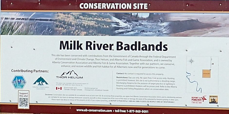
Information sign on an adjoining parcel of land, Milk River NA, 2024-10-15, P. Potter. 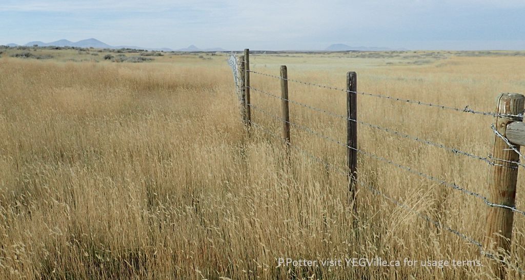
Fencing at the North Boundary, looking West, Milk River NA, 2024-10-15, P. Potter. 
Looking South toward the river along the OHV Track, Milk River NA, 2024-10-15, P. Potter. 
A visitor in the site, looking roughly NW, Milk River NA, 2024-10-15, P. Potter. 
Looking South towards the remainder of the NA, Milk River NA, 2024-10-15, P. Potter. 
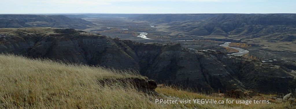
Looking South across the valley, Milk River NA, 2024-10-15, P. Potter. 
A single track trail leads down to the valley floor, middle image at bottom, Milk River NA, 2024-10-15, P. Potter.
