This 34-ha NA lies on the north shore of the Red Deer River and on part of an old channel of the river, between the northern part of the Gleniffer Reservoir Provincial Recreation Area to the southwest and the outlet of the Little Red Deer River to the northeast.
- Map of the Area
- Other Information
- Biophysical Observations (via iNaturalist)
- Site Statistics
- References
Map of the Area
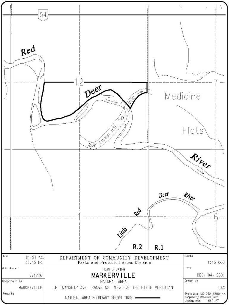
Any maps and map views are for general information only. Do not rely on them for navigation or to determine legal boundaries.
Other Information
Markerville Natural Area lies in the Central Parkland Subregion of the Parkland Natural Region and is located adjacent to the Red Deer River. Its lowlands are cut by old channels, floodways and gravel bars and support mainly balsam poplar and willow communities (Alberta Parks website, 2012).
The Order in Council Site Map for the area provides an interesting example of how the river changes. The 1896 township plan shows the river channel being south of the current channel. A portion of this prior river channel forms the southeast border of the NA.
Wildlife using this area include White-tailed and Mule Deer, Coyote, forest birds and shorebirds [1].
Markerville was named for the territorial dairy commissioner C. P. Marker in 1902 [2].
Biophysical Observations (via iNaturalist)
Are you a member of iNaturalist.ca? It is free to join and you can help nature by making observations with your smart phone.
If there are no or only a few observations, how about visiting and adding some? While there, complete a site inspection report (but read the Site Inspections terms and conditions first).
Observations & Projects for this Natural Area
- Observations for this Natural Area.
- No iNaturalist Projects.
Site Statistics
| Site Name | Markerville |
| Site Type | Natural Area |
| Subtype | Order-in-council (OC) |
| Natural Region(s) | Central Parkland |
| O.C. No. (Land Ref. Manual) | 861/76 |
| PASite ID (Map Ref #) | 124 |
| Site # (Parks Website) | 452 |
| Total Area | 33.15 ha. (81.91 ac.) |
| Steward-Status | |
| Recreation Activities | none noted |
| IUCN | II |
| Operated By | Parks Division |
| Notes and Comments |
References
The following links are provided as a courtesy but are not verified or endorsed by SAPAA. Clicking on the link will cause you to leave the SAPAA website. Primary source of information is: Government of Alberta – Information & Facilities – Markerville Natural Area | Alberta Parks (2026-01-05).
- 25 to 50 km from Red Deer – Nature Central . Markerville Natural Area (accessed 2026-02-05).
- Aubrey, Merrily K., ed. 2006. Concise Place Names of Alberta. Calgary, University of Calgary Press, p. 204.

Things change, the only constant. We see a river and at that instant of time, it seems immutable. Markerville Natural Area is an example of how a river laughs at this notion. The 1896 township map shows a very different course of the Red Deer River from what it follows now. In another 120 years, who knows.
LikeLiked by 1 person