This quarter-section site is named for the Redwater River which runs to the southwest of it. The Natural Area has gently rolling sand dunes interspersed with wet depressions.
- Map of the Area
- Other Information
- Dangerous and Disturbed
- Biophysical Observations (via iNaturalist)
- Site Statistics
- References
- Site Inspections
- Further Reading
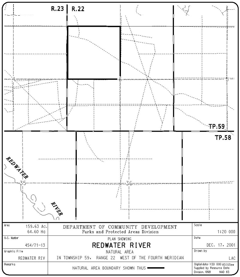
Map of the Area
Any maps and map views are for general information only. Do not rely on them for navigation or to determine legal boundaries.
Other Information
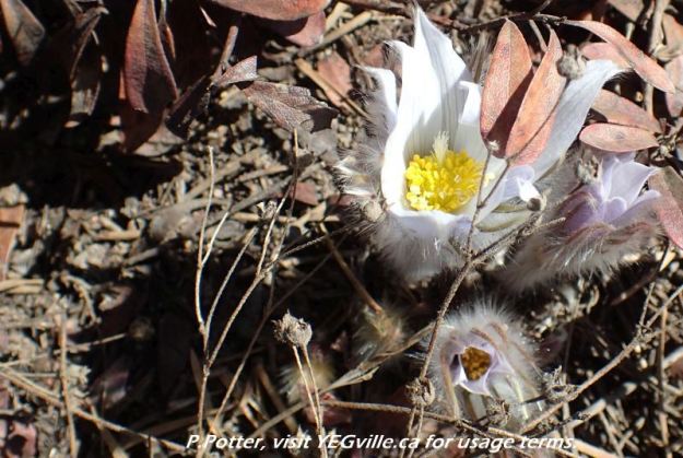
Redwater River Natural Area has gently rolling sand dunes interspersed with wet depressions. The forest cover is mainly second-growth aspen with open jack pine/lichen woodlands on dune crests and willow/sedge shrublands in depressions.
This site lies in the Boreal Forest Natural Region, Dry Mixedwood Subregion (Alberta Parks website, 2012).
It is located in a small constellation of Natural Areas with Halfway Lake, Taylor Lake and Crippsdale to the north and Halfmoon Lake to the south.
Dangerous and Disturbed
This site has heavy human disturbances. The open jack pine forests and sandy soil makes for ready OHV access. These tracks crisscross much of the site. An illegal shooting range probably contains tens of thousands of spent shells and a few hundred unspent ammunition cartridges [2]. The site should be approached with caution if active shooting is occurring and definitely should not be visited at night when alcohol and other substances may further impair the judgment of those pulling the triggers.
Biophysical Observations (via iNaturalist)
Are you a member of iNaturalist.ca? It is free to join and you can help nature by making observations with your smart phone.
If there are no or only a few observations, how about visiting and adding some? While there, complete a site inspection report (but read the Site Inspections terms and conditions first).
Observations & Projects for this Natural Area
- Observations for this Natural Area.
- No iNaturalist Projects.
Site Statistics
| Site Name | Redwater River (OC) |
| Site Type | Natural Area |
| Subtype | Order-in-council (OC) |
| Natural Region(s) | Dry Mixedwood |
| O.C. No. (Land Ref. Manual) | 454/71 |
| PASite ID (Map Ref #) | 365 |
| Site # (Parks Website) | 484 |
| Total Area | 64.60 ha. (159.63 ac.) |
| Steward-Status | |
| Recreation Activities | none noted |
| IUCN | II |
| Operated By | Parks Division |
| Notes and Comments |
References
The following links are provided as a courtesy but are not verified or endorsed by SAPAA. Clicking on the link will cause you to leave the SAPAA website. Primary source of information is: Government of Alberta – Information & Facilities – Redwater River Natural Area | Alberta Parks (2022-04-17).
Site Inspections
Further Reading

Exploring the sandy disturbances at Redwater NA, 2024-04-15, P. Potter. 
Looking west along an east-west running boundary trail at the north of Redwater River Natural Area, 2024-03-29, P. Potter. 
Looking east into the adjoining private property, Redwater River Natural Area, 2024-03-29, P. Potter. 
One of many ATV tracks, this one heading west, Redwater River Natural Area, 2024-03-29, P. Potter. 
A failed attempt to use an axe, Redwater River Natural Area, 2024-03-29, P. Potter. 
More dumping, Redwater River Natural Area, 2024-03-29, P. Potter. 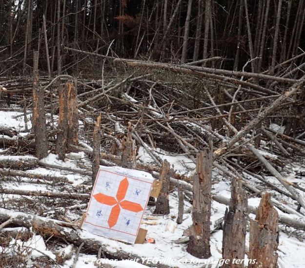
Trees ‘shot down’ in impromptu shooting range, Redwater River Natural Area, 2024-03-29, P. Potter. 
An ATV donut-pit with complete soil disturbance, Redwater River Natural Area, 2024-03-29, P. Potter. 
Targets within the impromptu shooting range, Redwater River Natural Area, 2024-03-29, P. Potter. 
Likely what was a sighting table within the impromptu shooting range, Redwater River Natural Area, 2024-03-29, P. Potter. 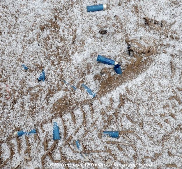
A few of the many hundred (thousand?) shell casings in an impromptu shooting range, Redwater River Natural Area, 2024-03-29, P. Potter. 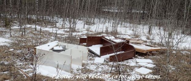
First of many instances of garbage dumping in Redwater River Natural Area, 2024-03-29, P. Potter.

This NA is an example of my interested in protected areas. Close to Edmonton, a metro area of 1M+ people. It, and a constellation of similar sites provides a wildlife corridor and refuge. Most importantly, it is a location for the 1M people to re-touch with our natural roots. Looking forward to visiting Red Water in the near future!
LikeLike