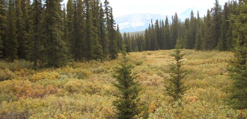
Scalp Creek Natural Area is a frost-active site with palsas and thermokarst in micro-hummocky and pockmarked terrain. It is 8 km northwest of the Ya Ha Tinda Ranch which is approximately 70 km west of Sundre in the Rocky Mountains.
- Map of the Area
- Biophysical Observations (via iNaturalist)
- Other Information
- Site Statistics
- References
- Further Reading
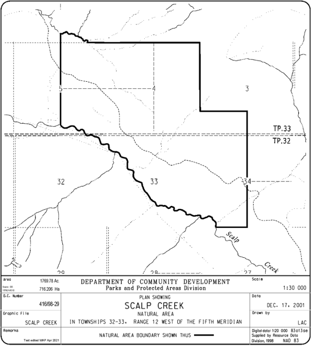
Map of the Area
Any maps and map views are for general information only. Do not rely on them for navigation or to determine legal boundaries.
Biophysical Observations (via iNaturalist)
Are you a member of iNaturalist.ca? It is free to join and you can help nature by making observations with your smart phone.
If there are no or only a few observations, how about visiting and adding some? While there, complete a site inspection report (but read the Site Inspections terms and conditions first).
Observations & Projects for this Natural Area
- Observations for this Natural Area.
- No iNaturalist Projects.
Other Information
The terrain types include sub-alpine colluvium, fluvial, morainal and organic terrain, supporting plant communities of grassland, wet meadows, Engelmann spruce-Rocky Mountain alpine fir-lodgepole pine stands and dwarf birch shrubland.
Arctic Alberta? Palsas are peat mounds with a permanently frozen peat and mineral soil core [1]. Thermokarst is a type of terrain characterized by very irregular surfaces of marshy hollows and small hummocks which form as ice-rich permafrost thaws [2]. Both of these geological phenomena are typical in a polar or subpolar zone. As a result, they are unique to Alberta and, like permafrost, sensitive to disturbance.
OHVs and Permafrost. Unfortunately, areas close to this NA are popular spots for motorized traffic and this NA is at risk for extreme disturbances as a result. Visitors are recommended to read the brochure on the area while planning a trip [3].
Site Statistics
| Site Name | Scalp Creek |
| Site Type | Natural Area |
| Subtype | Order-in-council (OC) |
| Natural Region(s) | Alpine; Subalpine |
| O.C. No. (Land Ref. Manual) | 416/98 |
| PASite ID (Map Ref #) | 464 |
| Site # (Parks Website) | 567 |
| Total Area | 716.21 ha. (1769.78 ac.) |
| Steward-Status | |
| Recreation Activities | none noted |
| IUCN | III |
| Operated By | Parks Division |
| Notes and Comments |
References
The following links are provided as a courtesy but are not verified or endorsed by SAPAA. Clicking on the link will cause you to leave the SAPAA website. Primary source of information is: Information & Facilities – Scalp Creek Natural Area | Alberta Parks (All links accessed on 2023-01-21).
- Wikipedia, Palsa.
- Wikipedia, Thermocarst.
- Alberta Government Brochure, Bighorn Backcountry Cutoff Creek Area Trail Map ,March 2017.

Scalp Creek is a pretty rugged and isolated place. I took a mountain bike up the access trail from the Ya Ha Tinda gate to the SEast corner of the NA but that’s where I had to turn back. One would need a couple of days to get into the Natural Area and see it properly. I believe it’s popular with equestrians. The photos are from September 2, 2005 and most were taken on the way into the NA. (T.Blake, email to SAPAA, January, 2023).
LikeLike