Schrader Creek-Red Deer River Natural Area comprises both OC and PNT sites on the creek and the river, protecting river bottom and floodplain ecosystems. The NA lies in the Boreal Forest Natural Region, Dry Mixedwood Subregion, 28 km west of Bowden.
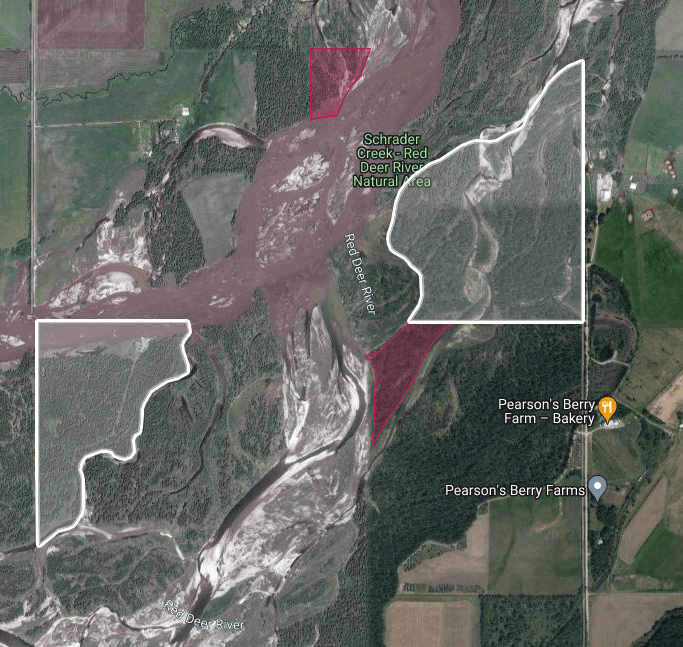
Map of the Area
Any maps and map views are for general information only. Do not rely on them for navigation or to determine legal boundaries.
Other Information
Schrader Creek-Red Deer River Natural Area encompasses river bottom and gravel bars on the Red Deer River and also includes part of the shoreline of Schrader Creek. Old river channels are vegetated by silverberry, willow and alder. Vegetation on the mainland is white spruce-balsam poplar forest; the gravel bars support open balsam poplar/yellow dryad communities.
Expanded But Not Updated. The original 0.86 ha NA was created in 1971 [1]. Sometime after that, it was expanded to 6.26 ha, based on the current Government of Alberta’s GIS information (see the Google map which uses this source). Although administratively expanded, the original OC was not amended. Email discussion with the Government of Alberta noted the following [2]:
- OC 454/71 (1971) is the only – and the most current – Order-in-Council for Schrader Creek – Red Deer River Natural Area.
- The site has not had a subsequent Order-in-Council; portions placed under reservation have not been incorporated into the designated natural area – they remain under reservation CLR880203 (formerly PNT880199).
Protected Notation (PNT) areas contribute another 46 ha for a total of 52 ha. Butcher Creek Natural Area is nearby and downstream from these sites.
Red Deer River is 740 km long and flows into the South Saskatchewan River. It was named for the numerous Elk noted by Hudson Bay employees. Elk reminded them of the Red Deer of their homeland [3]. The Cree place name is was-ka-sio meaning Elk River [4].
Biophysical Observations (via iNaturalist)
Are you a member of iNaturalist.ca? It is free to join and you can help nature by making observations with your smart phone.
If there are no or only a few observations, how about visiting and adding some? While there, complete a site inspection report (but read the Site Inspections terms and conditions first).
Observations & Projects for this Natural Area
- Observations for this Natural Area.
- No iNaturalist Projects.
Site Statistics
| Site Name | Schrader Creek – Red Deer River |
| Site Type | Natural Area |
| Subtype | Order-in-council (OC) |
| Natural Region(s) | Dry Mixedwood |
| O.C. No. (Land Ref. Manual) | 454/71 |
| PASite ID (Map Ref #) | 273 |
| Site # (Parks Website) | 463 |
| Total Area | 6.26 ha. (15.45 ac.) |
| Steward-Status | |
| Recreation Activities | none noted |
| IUCN | II |
| Operated By | Parks Division |
| Notes and Comments |
| Site Name | Schrader Creek – Red Deer River (PNT) |
| Site Type | Natural Area |
| Subtype | Protective Notation (PNT) |
| Natural Region(s) | Dry Mixedwood |
| O.C. No. (Land Ref. Manual) | N/A |
| PASite ID (Map Ref #) | 273 |
| Site # (Parks Website) | N/A |
| Total Area | 46.04 ha. (113.76 ac.) |
| Steward-Status | |
| Recreation Activities | |
| IUCN | IV*6 |
| Operated By | |
| Notes and Comments |
References
The following links are provided as a courtesy but are not verified or endorsed by SAPAA. Clicking on the link will cause you to leave the SAPAA website. Primary source of information is: Government of Alberta – Information & Facilities – Schrader Creek – Red Deer River Natural Area | Alberta Parks (2022-02-18).
- Alberta Parks – O.C. 454/71.
- Email exchange, “Re: 2023-SAPAA – Question (Q09) – FID 102 Schrader Creek”. Received by Frank Potter, 2023-07-20.
- Aubrey, Merrily K., ed. 2006. Concise Place Names of Alberta. Calgary, University of Calgary Press, p.271.
- Donovan, Larry. 2007. The Fascinating People and Stories Behind the Naming of Alberta. Canada: Dragon Hill Publ., p. 188.
