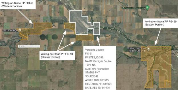
The stream forming Verdigris Coulee runs southeasterly from Verdigris Lake through the Natural Area (PNT), which protects its confluence with the Milk River. This PNT adjoins the central portion of Writing-on-Stone Provincial Park and is located about 10 km north of the U.S.–Canadian border.
- Map of the Area
- Other Information
- Biophysical Observations (via iNaturalist)
- Site Statistics
- References
- Further Reading
Map of the Area
Any maps and map views are for general information only. Do not rely on them for navigation or to determine legal boundaries.
Other Information
Green Crystalline Substance found at Verdigris Lake is the origin of the name of both the lake and the coulee [1]. Verdigris is the common name for blue-green, poisonous, copper-based pigment [2].
What is a Coulee? Coulee is a term applied rather loosely to different landforms that refer to a valley or drainage zone, often an intermittently dry ravine in a plains landscape. The word coulee comes from the Canadian French coulée, from the French couler, meaning ‘to flow’ [3].
Biophysical Observations (via iNaturalist)
Are you a member of iNaturalist.ca? It is free to join and you can help nature by making observations with your smart phone.
If there are no or only a few observations, how about visiting and adding some? While there, complete a site inspection report (but read the Site Inspections terms and conditions first).
Observations & Projects for this Natural Area
- Observations for this Natural Area.
- No iNaturalist Projects.
Site Statistics
| Site Name | Verdigris Coulee (PNT) |
| Site Type | Natural Area |
| Subtype | Protective Notation (PNT) |
| Natural Region(s) | Dry Mixedgrass |
| O.C. No. (Land Ref. Manual) | N/A |
| PASite ID (Map Ref #) | 398 |
| Site # (Parks Website) | N/A |
| Total Area | 761.62 ha. (1882.00 ac.) |
| Steward-Status | |
| Recreation Activities | |
| IUCN | |
| Operated By | |
| Notes and Comments |
References
The following links are provided as a courtesy but are not verified or endorsed by SAPAA. Clicking on the link will cause you to leave the SAPAA website. Primary source of information is the Government of Alberta (All links accessed on 2025-10-23).
- Aubrey, Merrily K., ed. Concise Place Names of Alberta. Calgary: University of Calgary Press, 2006, p. 337.
- Wikipedia, Verdigris.
- Wikipedia, Coulee.
