This small Natural Area is named for the Victoria Settlement historic site which is about 4 km upstream from it. It is located about 10 km southwest of the town of Smoky Lake.
- Map of the Area
- Other Information
- Biophysical Observations (via iNaturalist)
- Site Statistics
- References
- Further Reading
- Site Inspections

Map of the Area
Any maps and map views are for general information only. Do not rely on them for navigation or to determine legal boundaries.
Other Information
Victoria Settlement NA consists of an island in the North Saskatchewan River and a small parcel of land on the river’s north bank; access to the site is difficult.
Aboriginal, Methodist, HBC, Ukrainian. Lying along the North Saskatchewan River, this historic district illustrates several facets of the settlement of the West [1]. At this ancient Aboriginal meeting place, a Methodist Mission was founded in 1863. It was soon joined by a Hudson’s Bay Company trading post. These formed the nucleus for Métis and European, particularly Ukrainian, agricultural communities, characterized respectively by the use of river and square lots. It was named Victoria Settlement, after Queen Victoria [2].
Pakan the Name Away. When the post office arrived in 1887, the ‘Victoria’ name was confused with Victoria British Columbia. Subsequently, the name was changed in 1887 to Pakan in honour of a Cree Chief who refused to join the 1885 Northwest (Riel) Rebellion. On the river, the area thrived until the railroad ran through Smoky Lake to the north in 1918 after which the community slowly moved north to this more efficient mode of transportation [3, pp 115-116].
Biophysical Observations (via iNaturalist)
Are you a member of iNaturalist.ca? It is free to join and you can help nature by making observations with your smart phone.
If there are no or only a few observations, how about visiting and adding some? While there, complete a site inspection report (but read the Site Inspections terms and conditions first).
Observations & Projects for this Natural Area
- Observations for this Natural Area.
- No iNaturalist Projects.
Site Statistics
| Site Name | Victoria Settlement |
| Site Type | Natural Area |
| Subtype | Order-in-council (OC) |
| Natural Region(s) | Dry Mixedwood |
| O.C. No. (Land Ref. Manual) | 454/71 |
| PASite ID (Map Ref #) | 359 |
| Site # (Parks Website) | 485 |
| Total Area | 14.21 ha. (35.11 ac.) |
| Steward-Status | |
| Recreation Activities | none noted |
| IUCN | II |
| Operated By | Parks Division |
| Notes and Comments |

References
The following links are provided as a courtesy but are not verified or endorsed by SAPAA. Clicking on the link will cause you to leave the SAPAA website. Primary source of information is: Information & Facilities – Victoria Settlement Natural Area | Alberta Parks (All links accessed on 2025-10-23).
- Parks Canada, Victoria District National Historic Site.
- Wikipedia, Fort Victoria, Alberta.
- Donaldson-Yarmey, Joan. Backroads of Northern Alberta. Edmonton: Lone Pine Publishing, 1992.
Further Reading
- Victoria Settlement, History and Mandate.
- Retroactive (Exploring Alberta’a Past), Victoria Settlement.
- Tourisme Alberta,Victoria Settlement Provincial Historic Site
- The Canadian Encyclopedia, Victoria Settlement
Site Inspections

Methodist cemetery across the road (and up the hill) from the NA, Victoria Settlement NA, 2024-08-30, P. Potter., Victoria Settlement NA, 2024-08-30, P. Potter. 
Memorial in the methodist cemetery across the road (and up the hill) from the NA, Victoria Settlement NA, 2024-08-30, P. Potter. 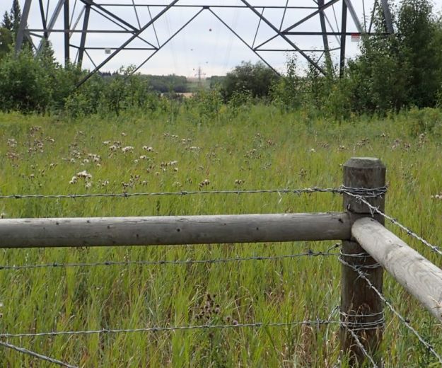
Looking south (across the North Saskatchewan River) and into the west border of the NA, Victoria Settlement NA, 2024-08-30, P. Potter. 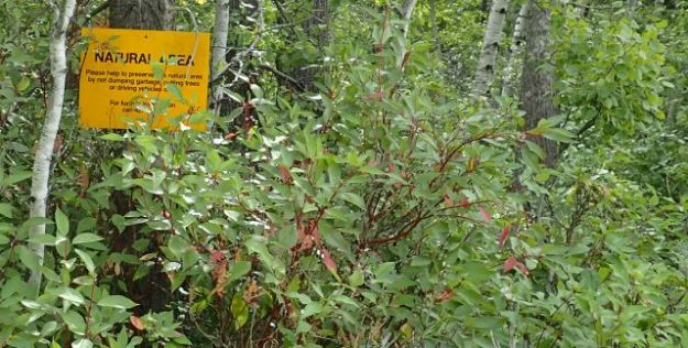
Boundary sign nearly obscured by the thick vegetation in the NA, Victoria Settlement NA, 2024-08-30, P. Potter. 
ATV Track that runs north of and parallel to, but not in, the NA, Victoria Settlement NA, 2024-08-30, P. Potter. 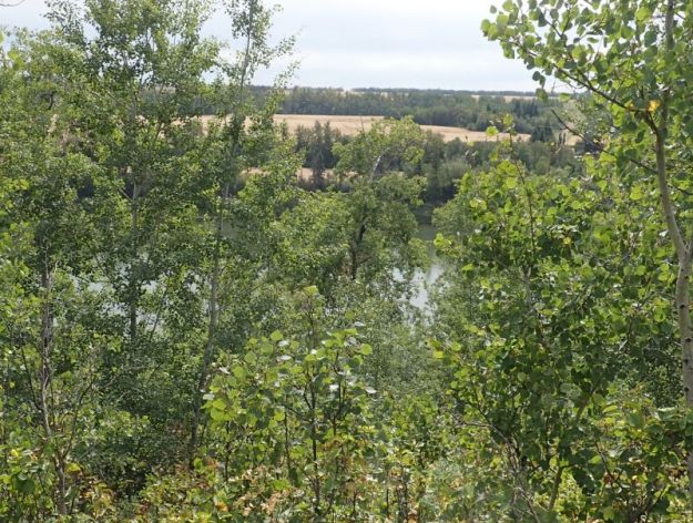
Looking down and south from the adjoining property into the eastern point of the NA, Victoria Settlement NA, 2024-08-30, P. Potter. 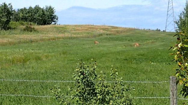
Looking north, along the power corridor, at two white tail deer that have yet caught my scent or sound; they are feeding on private land with the fence being the north border of the NA, Victoria Settlement NA, 2024-08-30, P. Potter. 
Looking north at the giant sentinels whose power lines pass through the NA, Victoria Settlement NA, 2024-08-30, P. Potter.
