An enclave within the Whitemud Falls Wildland Provincial Park, this Ecological Reserve shares a border with the Clearwater River Provincial Park in Saskatchewan. Located 80 km east of Fort McMurray, the site is remote and accessible only via air or by boat on the Clearwater River.
- Map of the Area
- Other Information
- Biophysical Observations (via iNaturalist.ca)
- Site Statistics
- References
- Further Reading
Map of the Area
Any maps and map views are for general information only. Do not rely on them for navigation or to determine legal boundaries.
Other Information
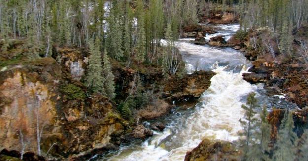
Interesting geology. Whitemud Falls Wildland Park [1], Whitemud Falls Ecological Reserve and Saskatchewan’s Clearwater River Provincial Park occupy a steep sided and deeply incised stretch of the Clearwater River valley. Here the river has eroded the underlying Devonian limestone and dolomites, creating the falls and a variety of karst features such as stacks (or “flowerpots”; rare in Alberta east of the Rockies), gullies, fissures and caves.
Rich in wildlife. More than 130 bird, four bat, 14 furbearer, six carnivore, three ungulate, three amphibian and one snake species are found in the area, where jack pine and aspen-dominated forests are the dominant vegetation.
Rare plants. Cold mineral springs with high salt content supply water to wetlands east of the falls. More than 20 rare, uncommon and disjunctive plant species have been recorded within the karst habitats of this area. Rare plants in the reserve include green spleenwort (Asplenium viride), western dwarf cliffbrake (Pellaea glabella subsp. occidentalis), northern oak fern (Gymnocarpium continentale) and several mosses [2].
Five Distinct Habitats. A survey in 1987 identified five distinct terrestrial habitats within the reserve which support one or more rare or disjunct plant species [2]:
- Erosional bedrock: dry rock faces, cooler and wetter gullies, and shallow-sandy soils.
- Dry sands plains and dunes: typically covered by jack pines.
- Sandy veeners: more well drained than the sandy plains and supporting dry aspen.
- Wet and poorly drained depressions: supporting Labrador tea (Rhododendron labradoricum).
- Wet mudflats, banks: Found along the Clearwater River.
Political Hay in 1987. 1987 was the Year of Wildlife Conservation in Canada designated by provincial and territorial wildlife ministers and their agencies. In Alberta, Wildlife ’87: Gaining Momentum was spearheaded by Cam Finlay, a well-known Alberta naturalist. More than a dozen new Natural Areas and several Ecological Reserves were designated during this period including these two [3].
Clearwater River is a designated Canadian Heritage River. The designation extends from near its source at Lloyd Creek in Saskatchewan to a point close to Ft. McMurray, at the confluence with the Christina River. The designation includes a portion of the lower section of the Christina River [4].
Clearwater is a descriptive name for the river (as well as the lake, mountain and pass). The name was likely selected to differentiate it from the more muddy Athabasca River into which it flows. The name is likely a translation from the original First Nations’ name. Other names for the river include Pelican and Lower Athabasca Rivers [5].
Restricted access and use. There are no public roads in the Reserve. Access is by jet boat, canoe and (in suitable locations on the river) float plane. Travel within the Reserve is by foot only. Overnight camping and open fires are prohibited in Ecological Reserves. There are no facilities on this site.
Biophysical Observations (via iNaturalist.ca)
Are you a member of iNaturalist.ca? It is free to join and you can help nature by making observations with your smart phone.
If there are no or only a few observations, how about visiting and adding some? While there, complete a site inspection report (but read the Site Inspections terms and conditions first).
Observations & Projects for this Natural Area
- Observations for this Natural Area.
- No iNaturalist Projects.
Site Statistics
| Site Name | Whitemud Falls |
| Site Type | Ecological Reserve |
| Subtype | Order-in-council (OC) |
| Natural Region(s) | Central Mixedwood |
| O.C. No. (Land Ref. Manual) | 616/88 |
| PASite ID (Map Ref #) | 489 |
| Site # (Parks Website) | 414 |
| Total Area | 864.85 ha. (2137.00 ac.) |
| Steward-Status | |
| Recreation Activities | Canoeing/kayaking, Hiking – backcountry |
| IUCN | IA |
| Operated By | Parks Division |
| Notes and Comments |

References
The following links are provided as a courtesy but are not verified or endorsed by SAPAA. Clicking on the link will cause you to leave the SAPAA website. Primary source of information is: Information & Facilities – Whitemud Falls Ecological Area | Alberta Parks (All links accessed on 2023-02-10).
- Alberta Parks, Information & Facilities – Whitemud Falls Wildland Provincial Park
- Downing, D.J., R.J. Bayer and D. H. Vitt. 1991. Rare and Disjunct Plants from Whitemud Falls Ecological Reserve, Northeastern Alberta, Canadian Field Naturalist 105(3): 376-381.
- History of Natural Areas and Ecological Reserves 1977-1994, SAPAA Newsletter No. 41 January 2021, p.4.
- Canadian Heritage Rivers System, Clearwater Heritage River Story Map.
- Aubrey, Merrily K., ed. Concise Place Names of Alberta. Calgary: University of Calgary Press, 2006, p. 69.
