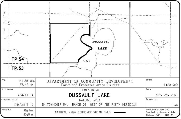
This site is located near the west end of Wabamun Lake, about 5 km north of Hwy 16. It occupies a small site located on the northwest quarter of the equally small Dussault Lake.
- Map of the Area
- Other Information
- Biophysical Observations (via iNaturalist.ca)
- Site Statistics
- References
Map of the Area
Any maps and map views are for general information only. Do not rely on them for navigation or to determine legal boundaries.
Other Information
The Natural Area is on the west side of Dussault Lake which is made up of two main bodies of water separated by a narrows. The north and east sides of the lake are Crown land with a small portion of private land in the southwest corner [1].
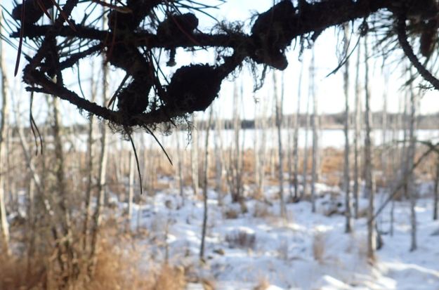
A site visit on January 12, 2021 indicated some off-highway vehicle impact with a track leading to the lake. Otherwise, there was limited human activity. Evidence of ungulate and Beaver activity was noted. OHV activity on the lake itself originates primarily from a cutline reaching the lake from the south, likely straddling the private and Crown land properties [2].
Dussault Lake Natural Area contains mainly black spruce-paper birch peatlands and sedge wetlands. The site lies in the Boreal Natural Region, Dry Mixedwood Subregion. (Alberta Parks website, 2012).
Biophysical Observations (via iNaturalist.ca)
Are you a member of iNaturalist.ca? It is free to join and you can help nature by making observations with your smart phone.
If there are no or only a few observations, how about visiting and adding some? While there, complete a site inspection report (but read the Site Inspections terms and conditions first).
Observations & Projects for this Natural Area
- Observations for this Natural Area.
- No iNaturalist Projects.
Site Statistics
| Site Name | Dussault Lake |
| Site Type | Natural Area |
| Subtype | Order-in-council (OC) |
| Natural Region(s) | Dry Mixedwood |
| O.C. No. (Land Ref. Manual) | 454/71 |
| PASite ID (Map Ref #) | 131 |
| Site # (Parks Website) | 139.3 |
| Total Area | 56.37 ha. (139.30 ac.) |
| Steward-Status | |
| Recreation Activities | none noted |
| IUCN | II |
| Operated By | Parks Division |
| Notes and Comments |
References
The following links are provided as a courtesy but are not verified or endorsed by SAPAA. Clicking on the link will cause you to leave the SAPAA website. Primary source of information is: Government of Alberta – Dussault Lake NA – Dussault Lake Natural Area | Alberta Parks (2022-02-17)
- Parkland County, Land Ownership Map, 2023 .
- Site visit, unpublished and unreported, January 12, 2021; F.Potter.

North-Central Alberta is the home of the pothole lake and Dussault is a good example of this. Water levels rise and fall while the shoreline does its best to try to fill in this left over from a glacier long since melted. While here, a nice place to enjoy an Alberta protected area.
LikeLike