Lloyd Creek Natural Area is a large (nearly 1,400 acres) irregularly shaped site, located southwest of Pigeon Lake. The much smaller Winfield Natural Area (PNT) is adjacent to the northwest corner of Lloyd Creek NA.
The topography is rolling, with a mixedwood land cover of mainly mature aspen and balsam poplar, and scattered white spruce on the uplands, and Alaskan birch, some river alder in the lower-lying or drainage areas. On well-drained slopes beaked hazelnut forms extensive stands; elsewhere it is scattered among a diversity of shrubs.
ATV tracks and a number of smaller, ill-defined trails in Lloyd Creek NA allow relatively easy access through the forest.
- Map of the Area
- Other Information
- Biophysical Observations (via iNaturalist)
- Site Statistics
- References
- Site Inspections
- Further Reading

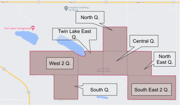
Map of the Area
Any maps and map views are for general information only. Do not rely on them for navigation or to determine legal boundaries.
Other Information
Lloyd Creek Natural Area (ca. 580 ha) is made up of rolling uplands incised by two meltwater channels (part of Twin Lakes). The creek valley, with its steep banks and variety of aspects, supports several forest types, including mature and young upland forests of white spruce, lodgepole pine, paper birch, aspen and balsam poplar, which provide good wildlife habitat.
Winfield is adjacent to and northwest of Lloyd Creek. A large portion of this quarter- section Natural Area covers Twin Lake. The County of Wetaskiwin has a Tourism and Commercial Development Lease on the PNT. The Twin Lakes County Park is built on the PNT and the two quarter sections to the East.

Biophysical Observations (via iNaturalist)
Are you a member of iNaturalist.ca? It is free to join and you can help nature by making observations with your smart phone.
If there are no or only a few observations, how about visiting and adding some? While there, complete a site inspection report (but read the Site Inspections terms and conditions first).
Observations & Projects for this Natural Area
- Lloyd Creek Natural Area.
- Winfield PNT.
- No iNaturalist Projects.
Site Statistics
Lloyd Creek
| Site Name | Lloyd Creek |
| Site Type | |
| Subtype | Natural Area |
| Natural Region(s) | Order-in-council (OC) |
| O.C. No. (Land Ref. Manual) | Central Mixedwood |
| PASite ID (Map Ref #) | 454/71 |
| Site # (Parks Website) | 270 |
| Total Area | 1432.67 |
| Steward-Status | |
| Recreation Activities | |
| IUCN | none noted |
| Operated By | II |
| Notes and Comments | Parks Division |
Winfield Natural Area

| Site Name | Winfield (PNT) |
| Site Type | Natural Area |
| Subtype | Protective Notation (PNT) |
| Natural Region(s) | Central Mixedwood |
| O.C. No. (Land Ref. Manual) | N/A |
| PASite ID (Map Ref #) | 244 |
| Site # (Parks Website) | N/A |
| Total Area | 65.00 ha. (160.62 ac.) |
| Steward-Status | |
| Recreation Activities | |
| IUCN | |
| Operated By | |
| Notes and Comments |
References
The following links are provided as a courtesy but are not verified or endorsed by SAPAA. Clicking on the link will cause you to leave the SAPAA website. Primary source of information is: Government of Alberta – Information & Facilities – Lloyd Creek Natural Area | Alberta Parks (2026-01-27).
Site Inspections
Further Reading

Looking N into the site from TWP 460 at the SE corner at an ATV track, Lloyd Creek NA, 2024-09-30, P. Potter. 
Looking S along RR 13 and at a boundary sign at the NE corner of the site, Lloyd Creek NA, 2024-09-30, P. Potter. 
Looking S and a steep climb just as RR 13 enters the site, Lloyd Creek NA, 2024-09-30, P. Potter. 
Looking E along the N border of the site at a flood ATV track with braiding occurring, Lloyd Creek NA, 2024-09-30, P. Potter. 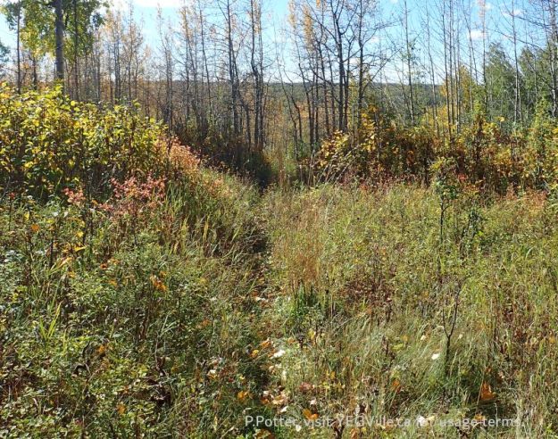
Looking S across the valley where TWP 460 runs at a single-track trail, likely originally a game trail broadened by human use, Lloyd Creek NA, 2024-09-30, P. Potter

Natural Areas have different levels of protection and are often close or even adjacent to each other. Such is this case with these two. The large Lloyd Creek dominates the area and has Order in Council Status. Winfield is smaller and only has Protected Notation Status. Visit the SAPAA website to read more on what these status mean to preserving these ever threatened Protected Areas.
LikeLike