The designations of a protected area is an act of trust from one generation to another. Once lost, the biodiversity, habitat, and cultural importance disappears. Six former areas now enjoy higher level protection while six have been downgraded since 2010.

Transferred to Higher Level Protection
Alberta’s legislative framework provides for different degrees of protection. For those unfamiliar with this framework, Protected Areas provides a handy guide. The following areas no longer exist because they have been incorporated into an area of greater protection such as a provincial park.
| Protected Area | Converted to… | 2011 Description |
| Big Sagebrush | Incorporated into the Castle Wildland Provincial Park with the Park’s designation in 2017 | Big Sagebrush |
| Black Fox Island (OC) | Incorporated into the Sir Winston Churchill Provincial Park. Proposed in 2009, exact date of Expansion Unknown. | Black Fox Island |
| High Island (OC) | Incorporated into the Sir Winston Churchill Provincial Park. Proposed in 2009, exact date of Expansion Unknown. | High Island |
| Lac La Biche Islands (PNT) | Incorporated into the Sir Winston Churchill Provincial Park. Proposed in 2009, exact date of Expansion Unknown. | Lac La Biche Islands |
In Memory of Lost Natural Areas
The following former natural areas have lost their designations. This loss includes conversion into other forms of public lands such as a PRA. Unfortunately, the carrying capacity of the lands to support biodiversity diminishes in direct proportion to the amount of human interaction – in particular, non-foot-based travel such as OHVs.
Manly Corners
Manly Corners is a good case study in the importance of protecting natural areas. From a biodiversity perspective, it had everything going for it including the following features noted on the site:
- moderately rolling, pitted outwash moraine – knob and kettle topography
- ponds and marshes in depressions, variety of wetlands
- upland aspen or aspen-balsam poplar and white spruce/horsetail forests with well developed understories
- diverse vegetation and wildlife: paper birch/willow stand; willow/sedge wet shrubland; black spruce/willow/Labrador tea lowland forest
The above, proximity to Edmonton and a relatively undisturbed condition made this an ideal area to protect. This remained more or less the state of affairs for 40 years until the Assistant Deputy Minister with Tourism, Parks and Recreation (ministry of the day) gave direction to cancel the reservation in December 2012.
A search of the press releases for this time yields no references to this change nor was SAPAA notified to update its records. A site visit in December 12, 2020 had this to say:
Manly is a former locality in Parkland County, Alberta and was named for Manley, England. The first post office opened in Manly in 1908. ‘Corner’ was added to the name of the area as this is the beginning of Highway 43 which goes north to the Alaska Highway. [1, adapted]. The area to the west is also a county reserve. The area to the north is private land in Lac Ste. Anne County.
Unfortunately the area has been chewed up by ATVs. In some areas the ruts are two or more feet deep. To get around these ruts, ATVs are expanding the trail and causing further erosion. Walking in this area is precarious. This is unfortunate as the area is large with numerous gullies and wetlands. Manly is now a single use – OHV only – area, the variety of wetlands and diverse wildlife now sharing the habitat with the constant buzz of the quad.
Notes from December 12, 2020 site visit, F. Potter
North Bruderheim
Initially announced in 2007, two NAs were proposed to be de-listed in exchange for the expansion of other areas [1]. This NA was first established 1971 (OC 454/71), but was disestablished via OC 273/2012. OC 274/2012 created the North Bruderheim Provincial Recreation Area.
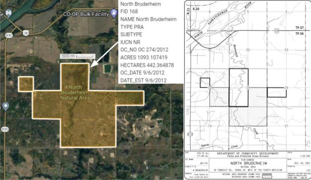
- Newsletter reference: Loss of Astotin and part of North of Bruderheim Natural Areas, SAPAA Newsletter No. 18, September 2007, p. 4.
Redwater
In 2005, the Redwater NA seemed to have been a success story of allowing multi-use access to public lands. SAPAA hosted a field trip in which the Friends of Redwater Natural Area demonstrated the seeming success to educate users on trail etiquette and permissible activities [1]. A year later, increasingly the supposedly ‘off-limits’ NA was being encroached upon by OHVs [2].
Fast forward to 2012, and perhaps admitting defeat, the government de-listed Redwater and turned it entirely over to OHVs. This NA was first established by 1971(OC 454/71) but was disestablished via OC 271/2012.
Effectively, this public land now has a single recreational use – operating OHVs.
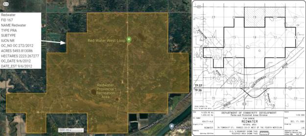
- Field Trip to Redwater Natural Area Saturday, June 18, 2005, SAPAA Newsletter No. 12, April 2005, p. 1.
- Summer field trip to Redwater Sandhills Natural Area, June 10 (2006), SAPAA Newsletter No. 15, September 2006, p. 1.
Saskatoon Mountain
Located west of Grand Prairie, Saskatoon Mountain NA was designated as such in 1998. The county of Grand Prairie later requested that the NA be turned into a PP because of problematic OHV disturbances. A public consultation was held and in 2018 the NA was converted to a PRA. The Land Reference Manual indicates that OHV use is restricted to the west side of Range Road 92.
As former SAPAA President, Alison Dinwoodie, wrote in a 2014 article on the area, while the west side of the area was already disturbed, the east side may be a tempting destination for OHVs. This will increase as the west side becomes increasingly degraded [1].

- Saskatoon Mountain NA: Is this the Shape of Things to Come?, SAPAA Newsletter No. 30, August 2014, pp. 4-5.
