Alberta Forestry and Parks is playing catch up in remediate sites that have fallen into disrepair or abuse. Efforts included trail management plans, infrastructure upgrades, and improved signage at various natural areas. 5 Natural Areas (out of 138) have benefitted from these enhancements to ensure visitor safety and ecological protection.
Success and Progress in Managing Alberta’s Protected Areas
by Lands Operations Division, Alberta Forestry and Parks.

This past year, efforts were undertaken by Alberta Forestry and Parks to enhance visitor
use and management in Alberta’s Natural Areas. This update provides an overview of
some of that work.
To access general information about these sites, please visit: Parks System | Alberta Parks. For other Crown lands information please see Public land management, or to report public safety incidents, illegal activity and enforcement concerns please contact 310-LAND (5263).
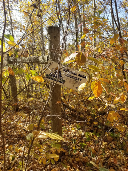
Bilby Natural Area
Bilby Natural Area is a protected site that spans 122 hectares near Onoway, Alberta.
The site is primarily covered by deciduous or mixedwood forest, and it is stewarded by
the Onoway & District Fish & Game Association. Motorized and non-motorized
recreational activities such as quadding, hiking, and equestrian riding occur within the
Natural Area. To reduce the potential for user conflicts and to protect ecological
features, numerous upgrades were recently completed within the Natural Area.
The mixed-use trail was widened to meet standards outlined in the Alberta Trail
Development Guidelines for Public Land (2019). This work improved sightlines and
created safer two-way travel among trail users. Trails were also designated as either
mixed-use or non-motorized, and signage was installed to indicate the authorized uses.
Damaged and outdated signs were also removed and replaced.
Beaver activity in the area led to the flooding of Kilini Creek, submerging part of the
original trail system. To reduce the impact of motorized trail users on the creek and
riparian area, a new trail connection was created outside the floodplain. Additionally, the western and northern boundaries of the Natural Area were fenced to prevent motorized access to the creek and riparian area.
Halfmoon Lake Natural Area
This is a scenic and ecologically diverse site located approximately 40 kilometres northeast of Edmonton. It spans 331 hectares and is part of the Dry Mixedwood Natural Sub-Region. There is a mix of forest cover, open area, and very sandy soils on the shore of Halfmoon Lake. Part of Halfmoon Lake’s shoreline of is also within the Natural Area. The stewards of this site are the Rainbow Equitation Society.
The Department completed a Trail Management Plan for the Halfmoon Lake Natural Area, and the trails were designated under the Trails Act in September 2025. A significant portion of the existing signage within the Natural Area was either damaged, inconsistent, or missing, making it difficult to identify authorized uses and clearly delineate the Natural Area boundary. A signage plan was completed as part of the trail management planning process, which included signage for the Natural Area boundary, OHV restrictions, and trail etiquette.

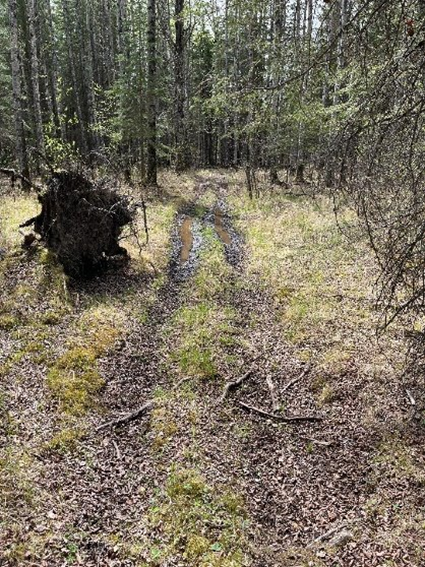
Centre of Alberta Natural Area
The site (3.25 km2) is located at the geographical centre of Alberta, roughly 25 kilometres northwest of Fort Assiniboine within Woodlands County. The Natural Area is within the Lower Foothills Sub-Region, along Clearwater Creek. It features two main recreation trails leading to the geographical centre of Alberta: one trail is for motorized use and one is for non-motorized use.
Over the years, many Natural Area signs have become damaged, outdated, or disappeared altogether. As the non-motorized trail was not regularly maintained, parts became overgrown and lacked signage making it difficult for visitors to navigate to the trails.
Trail assessments identified several wet areas along the existing trail that were impassable and impacting wetlands. To improve the recreational experience while protecting these sensitive areas, work is underway in fall 2025 to mulch and widen the trail, reroute sections to higher ground with better soils, and install boardwalks across wet areas.
Damaged infrastructure—including broken signs, picnic tables, and an unusable outhouse—has also been removed. A new outhouse was installed along the motorized trail and planning is underway for new signage and other infrastructure.
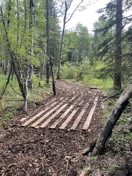
(Note: This photo is of a boardwalk section during construction and is not yet complete. Work is projected to be completed by the end of October, 2025.)
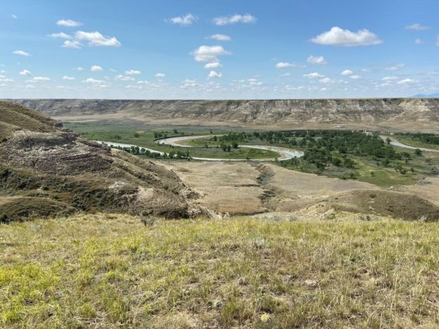
Milk River Natural Area
This is a vast and ecologically rich protected site located about 125 kilometres southeast of the Town of Milk River. It spans over 5,344 hectares (13,205 acres). The area is an exemplary intact area of the Dry Mixedgrass Natural Sub-Region, and it contains an incredible diversity of geological, biological, and archaeological features. The area is stewarded by the Milk River Management Committee.
The Milk River Natural Area & Kennedy Coulee Ecological Reserve Operational Management Plan was originally completed in 1992. In the past 33 years, a great deal of change has occurred leading to the need for an updated management plan. These updates are nearing completion and should be approved for release in the near future.
Revisions included descriptions of the role of the Management Committee and subset Management Society, formalized site inventory and monitoring strategies, improved range management information, fire management strategies, and access and recreation management strategies, among others. Further planning is underway for updated signage regarding site regulations, wayfinding and educational information. Some minor infrastructure improvements are being planned as well.
Red Rock Coulee Natural Area
A striking and unique landscape located about 56 kilometres southwest of Medicine Hat. It is known for its surreal scenery and fascinating geological formations, giant red sandstone boulders (up to 2.5 meters in diameter) which are scattered across grassy knolls. The intact grasslands offer impressive viewscapes across the prairies of southern Alberta, and to the Sweetgrass Hills of Montana. These features are driving increased visitation.
The site refurbishment project focused on addressing the site’s aging infrastructure. Improvements included replacing damaged sections of fencing and upgrading them to meet wildlife-friendly specifications, upgraded gates, new picnic tables, new rock barriers around the parking lot, and new boundary signs were installed. These updates ensure that public safety and wildlife hazards are reduced and will reduce potential ecological impacts to the site.
Further planning is underway for updated signage regarding site regulations and educational information.


Pingback: 2025 AGM Registration | SAPAA
Pingback: Alberta Rural MLAs and SAPAA – 2026-03-20 | SAPAA