These three PNT sites are in close proximity to each other, but not adjoined. They are roughly 200 km east of Red Deer and about 50 km west of the Saskatchewan provincial border.
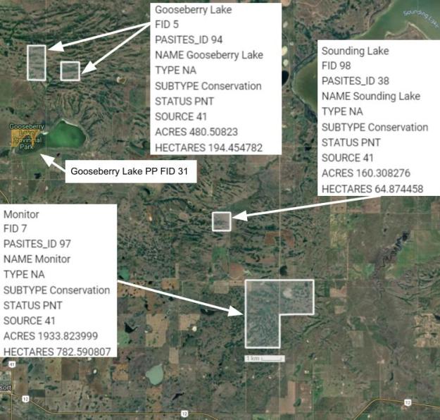
Map of the Area
Any maps and map views are for general information only. Do not rely on them for navigation or to determine legal boundaries.
Biophysical Observations (via iNaturalist)
Are you a member of iNaturalist.ca? It is free to join and you can help nature by making observations with your smart phone.
If there are no or only a few observations, how about visiting and adding some? While there, complete a site inspection report (but read the Site Inspections terms and conditions first).
Observations & Projects for this Natural Area
- Observations for Gooseberry Lake (PNT) NA.
- Observations for Monitor (PNT) Natural Area.
- Observations for Sounding Lake (PNT) Natural Area.
- No iNaturalist Projects.
Other Information
Gooseberry Lake Provincial Park, south of its namesake PNT, was one of the first eight provincial parks that were established in 1932. The other seven were Aspen Beach, Park Lake, Sylvan Lake, Saskatoon Island, Lundbreck Falls, Ghost River and Hommy [1]. The name is likely descriptive of the plant found in the area [2, p. 133].
Hamlet of Monitor was originally named Sounding Lake and was changed to align with the new CPR Station. The name is likely part of a battleship-naming theme in the area which includes Consort and Fleet [2, p. 216].
Sounding Lake is an English Translation of the original Cree name. Various mythologies exist as to its origin including the place where buffalo were born [2, p. 300].
Site Statistics
| Site Name | Gooseberry Lake (PNT) |
| Site Type | Natural Area |
| Subtype | Protective Notation (PNT) |
| Natural Region(s) | Northern Fescue |
| O.C. No. (Land Ref. Manual) | N/A |
| PASite ID (Map Ref #) | 94 |
| Site # (Parks Website) | N/A |
| Total Area | 194.45 ha. (480.51 ac.) |
| Steward-Status | |
| Recreation Activities | |
| IUCN | |
| Operated By | |
| Notes and Comments |
| Site Name | Monitor (PNT) |
| Site Type | Natural Area |
| Subtype | Protective Notation (PNT) |
| Natural Region(s) | Northern Fescue |
| O.C. No. (Land Ref. Manual) | N/A |
| PASite ID (Map Ref #) | 97 |
| Site # (Parks Website) | N/A |
| Total Area | 782.59 ha. (1933.82 ac.) |
| Steward-Status | |
| Recreation Activities | |
| IUCN | |
| Operated By | |
| Notes and Comments |
| Site Name | Sounding Lake (PNT) |
| Site Type | Natural Area |
| Subtype | Protective Notation (PNT) |
| Natural Region(s) | Northern Fescue |
| O.C. No. (Land Ref. Manual) | N/A |
| PASite ID (Map Ref #) | 38 |
| Site # (Parks Website) | N/A |
| Total Area | 65.00 ha. (160.31 ac.) |
| Steward-Status | |
| Recreation Activities | |
| IUCN | |
| Operated By | |
| Notes and Comments |
References
The following links are provided as a courtesy but are not verified or endorsed by SAPAA. Clicking on the link will cause you to leave the SAPAA website. Primary source of information is the Government of Alberta. (All links accessed on 2025-10-30).
- History of Natural Areas and Ecological Reserves 1977-1994, SAPAA Newsletter No. 41 January 2022, p. 6.
- Aubrey, Merrily K., ed. Concise Place Names of Alberta. Calgary: University of Calgary Press, 2006, pp. 133, 216, 300.
