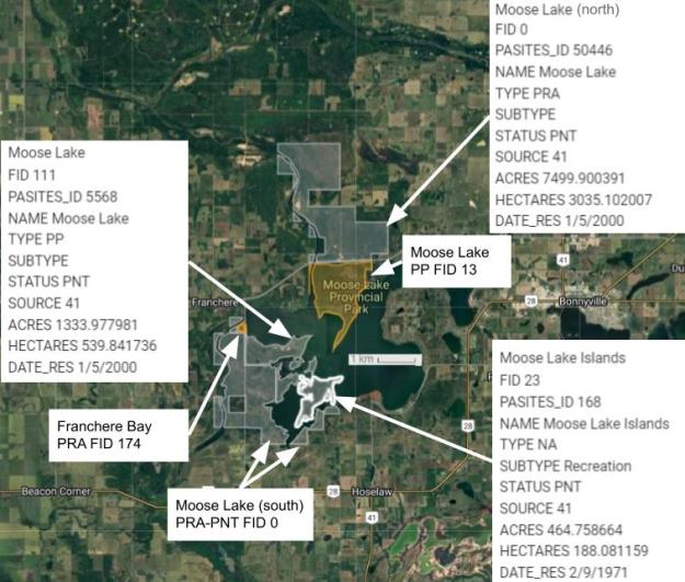
This PNT Natural Area occupies several islands in the southwest corner of Moose Lake, just west of Bonnyville. Along with Moose Lake Provincial Park it comprises six protected areas in the vicinity of Moose Lake, as shown on the map.
- Map of the Area
- Other Information
- Biophysical Observations (via iNaturalist)
- Site Statistics
- References
- Further Reading
Map of the Area
Any maps and map views are for general information only. Do not rely on them for navigation or to determine legal boundaries.
Other Information
Lac d’Orignal was the original French name for this lake inspired by the abundance of moose in the area. With an extensive shoreline, the lake comprises four main bays and has a maximum depth of 19 m and a mean depth of 5.6 m. Good opportunities for trapping and hunting were responsible for this being one of the earliest European settlements known to Alberta [1].
Moose Lake(s) in Alberta. Confusingly, there are at least three, and possibly more, Moose Lakes in Alberta. This one is located west of Bonnyville and has 21 Individual land parcels spread across five distinct Crown land designations. Moose Lake PP is at the centre. It is often discussed with its PRA neighbour, Franchere Bay. To the north of the PP is the northern portion of the Moose Lake PRA-PNT. Its larger southern portion adjoins Franchere Bay as well as the similarly named Moose Lake PP-PNT.
Moose Lake Islands (and Friends). Finally, there is the Moose Lake Islands Natural Area. As to the history of how the PP-PNT and PRA-PNT got to where they are, the Alberta Government provided the following notes [3]:
- Crown Land Reservation (CLR) 000276, CLR 000277, CLR 010484 these are for the proposed Moose Lake Provincial Park expansion.
- CLR 0200025 – Snowmobile Trails
- CLR 160118 – Multi Species Habitat Conservation, Fish and Wildlife out of the St Paul office.
- CLR 060718 – Important Colonial Nesting Bird Breeding Area.
Biophysical Observations (via iNaturalist)
Are you a member of iNaturalist.ca? It is free to join and you can help nature by making observations with your smart phone.
If there are no or only a few observations, how about visiting and adding some? While there, complete a site inspection report (but read the Site Inspections terms and conditions first).
Observations & Projects for this Natural Area
- Moose Lake Islands (PNT) Observations..
- No iNaturalist Projects.
Site Statistics
| Site Name | Moose Lake Islands (PNT) |
| Site Type | Natural Area |
| Subtype | Protective Notation (PNT) |
| Natural Region(s) | Dry Mixedwood |
| O.C. No. (Land Ref. Manual) | N/A |
| PASite ID (Map Ref #) | 168 |
| Site # (Parks Website) | N/A |
| Total Area | 188.08 ha. (466.76 ac.) |
| Steward-Status | |
| Recreation Activities | |
| IUCN | |
| Operated By | |
| Notes and Comments |
References
The following links are provided as a courtesy but are not verified or endorsed by SAPAA. Clicking on the link will cause you to leave the SAPAA website. Primary source of information is: Government of Alberta (Links accessed 2026-01-15).
- Alberta Lake Management Society, Moose Lake Report (2020)
- Wikipedia, Moose Lake (Alberta)
- Email exchange – Forestry Parks, and Tourism. “Re: SAPAA Asks – Moose Lake PNTs – FID 0 and FID 111” Received by F.Potter.
