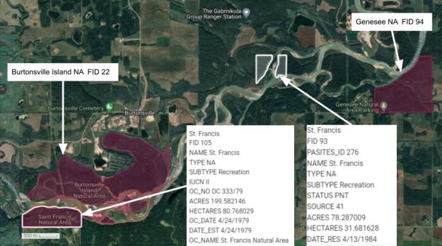
Two non-contiguous sites make up this OC and PNT NA. They are both on the North Saskatchewan River and 2-5 km west of Genesee.
- Map of the Area
- Biophysical Observations (via iNaturalist)
- Other Information
- Site Statistics
- References
- Further Reading
Map of the Area
Any maps and map views are for general information only. Do not rely on them for navigation or to determine legal boundaries.
Biophysical Observations (via iNaturalist)
Are you a member of iNaturalist.ca? It is free to join and you can help nature by making observations with your smart phone.
If there are no or only a few observations, how about visiting and adding some? While there, complete a site inspection report (but read the Site Inspections terms and conditions first).
Observations & Projects for this Natural Area
- Observations for this Natural Area – OC Portion.
- Observations for this Natural Area – PNT Portion.
- No iNaturalist Projects.
Other Information
This site lies in the Boreal Forest Natural Region, Dry Mixedwood Subregion. (Alberta Parks website, 2012).
Why St. Francis was chosen as the name for these two areas is unclear. The community of St. Francis is more than 13 km to the southeast. Burtonsville Island Natural Area lies between the OC and PNT portions which are separated by more than 5 km.
Site Statistics
| Site Name | St. Francis |
| Site Type | Natural Area |
| Subtype | Order-in-council (OC) |
| Natural Region(s) | Dry Mixedwood |
| O.C. No. (Land Ref. Manual) | 333/79 |
| PASite ID (Map Ref #) | 276 |
| Site # (Parks Website) | 465 |
| Total Area | 81.96 ha. (202.52 ac.) |
| Steward-Status | |
| Recreation Activities | none noted |
| IUCN | II |
| Operated By | Parks Division |
| Notes and Comments |
| Site Name | St. Francis (PNT) |
| Site Type | Natural Area |
| Subtype | Protective Notation (PNT) |
| Natural Region(s) | Dry Mixedwood |
| O.C. No. (Land Ref. Manual) | N/A |
| PASite ID (Map Ref #) | 276 |
| Site # (Parks Website) | N/A |
| Total Area | 31.68 ha. (78.29 ac.) |
| Steward-Status | |
| Recreation Activities | |
| IUCN | IV*6 |
| Operated By | |
| Notes and Comments |

References
The following links are provided as a courtesy but are not verified or endorsed by SAPAA. Clicking on the link will cause you to leave the SAPAA website. Primary source of information is: Information & Facilities – St. Francis Natural Area | Alberta Parks (All links accessed on 2025-10-30).
