The forest cover is mainly second-growth aspen with scattered stands of jack pine and mature balsam poplar forest along the river edge. This Natural Area is located across the river from Fort Assiniboine Sandhills Wildland Provincial Park.
- Map of the Area
- Other Information
- Biophysical Observations (via iNaturalist)
- Site Statistics
- References
- Further Reading
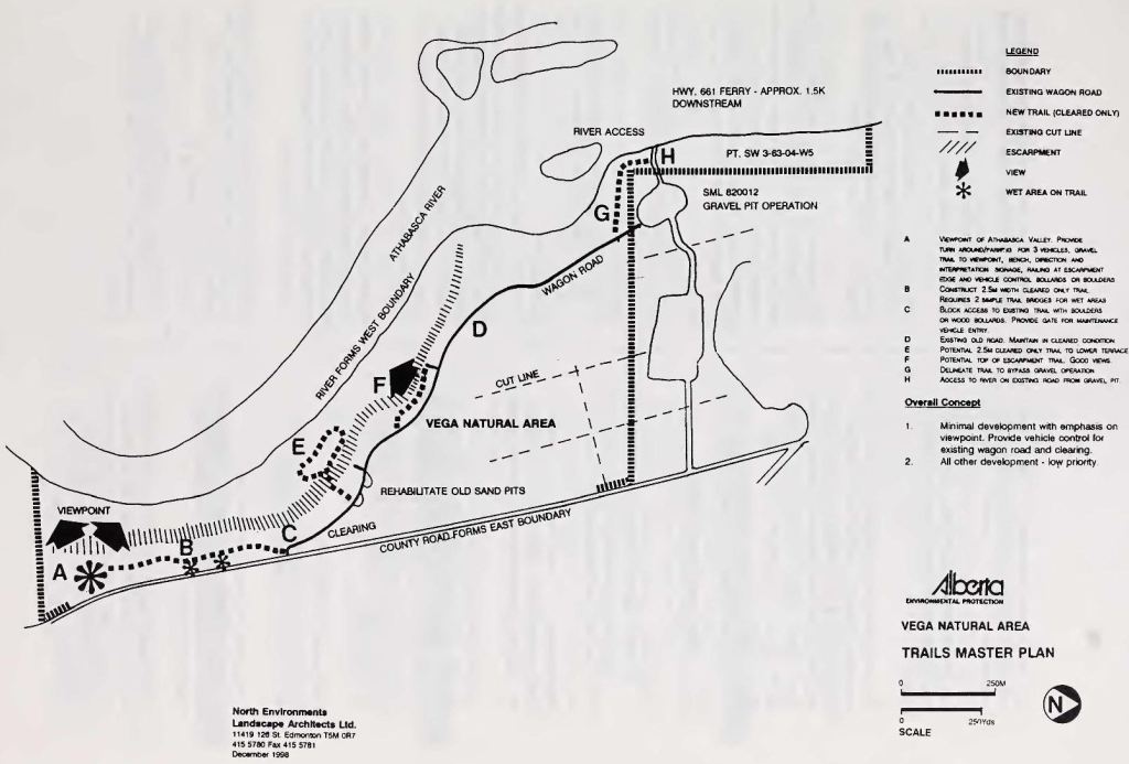
Map of the Area
Any maps and map views are for general information only. Do not rely on them for navigation or to determine legal boundaries.
Other Information
Vega Natural Area (180 ha) lies immediately across the river from Fort Assiniboine Sandhills Wildland Park and includes terraces of the Athabasca River and adjacent sandy upland. The site has 80 ha of riverine forest; mainly second-growth aspen with scattered stands of jack pine occupying the uplands and mature balsam poplar forest occurring along the river edge. This site was established or expanded as part of the Special Places program (Alberta Parks website, 2012).
Biophysical Observations (via iNaturalist)
Are you a member of iNaturalist.ca? It is free to join and you can help nature by making observations with your smart phone.
If there are no or only a few observations, how about visiting and adding some? While there, complete a site inspection report (but read the Site Inspections terms and conditions first).
Observations & Projects for this Natural Area
- Observations for this Natural Area.
- No iNaturalist Projects.
Site Statistics
| Site Name | Vega |
| Site Type | Natural Area |
| Subtype | Order-in-council (OC) |
| Natural Region(s) | Central Mixedwood |
| O.C. No. (Land Ref. Manual) | 48/97 |
| PASite ID (Map Ref #) | 579 |
| Site # (Parks Website) | 569 |
| Total Area | 101.63 ha. (251.13 ac.) |
| Steward-Status | |
| Recreation Activities | Hiking – front country |
| IUCN | II |
| Operated By | Parks Division |
| Notes and Comments |
References
The following links are provided as a courtesy but are not verified or endorsed by SAPAA. Clicking on the link will cause you to leave the SAPAA website. Primary source of information is: Government of Alberta – Information & Facilities – Vega Natural Area | Alberta Parks (2025-05-29).

According to sciencealert.com, the length of a curve in a river is equal to about six times the width of the channel. Just north of this Natural Area you get to test this as there are two curves. The North bound river goes east, south, east, north, east, and then back north. Seems longer than 6X but you be the judge!
LikeLike