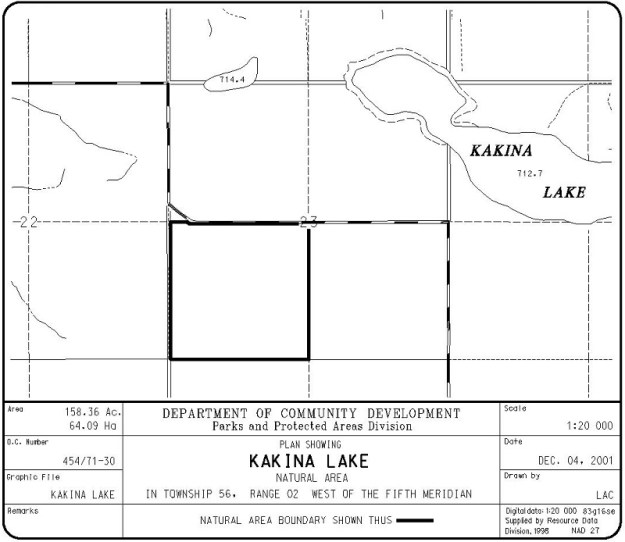
Situated southwest of, but not on, Kakina Lake, this Natural Area is about 15 km north of Onoway in the County of Lac Ste. Anne.
Map of the Area
Any maps and map views are for general information only. Do not rely on them for navigation or to determine legal boundaries.
Other Information
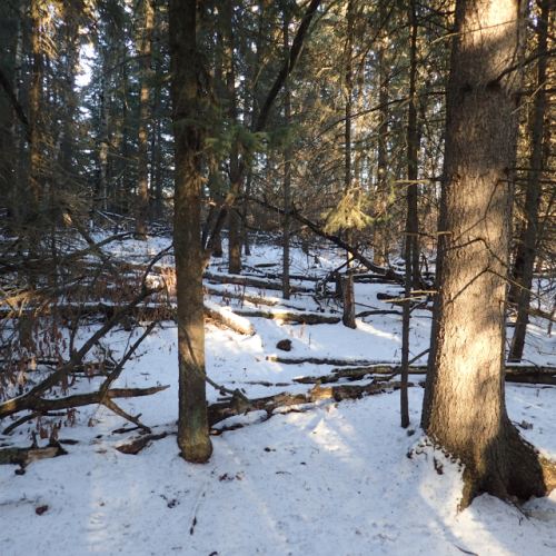
This natural area has rolling hummocky moraine dissected from northwest to southeast by a poorly-drained lowland area. There is upland balsam poplar forest with some aspen and a dense shrub layer.
A Little Disturbed Name. A site visit in December 2020 indicated little human disturbance [1]. As for the name of the NA, it presumably derives from that of the nearby lake which was recorded in the 1904 field notes of the Dominion Land Survey as “Lake Kakinasakahigan” (“sakahigan” means “lake”); the name was later shortened by the surveyor. It began appearing on Department of the Interior maps by 1917 and was formerly adopted in 1950 by the federal government [2].
Biophysical Observations (via iNaturalist)
Are you a member of iNaturalist.ca? It is free to join and you can help nature by making observations with your smart phone.
If there are no or only a few observations, how about visiting and adding some? While there, complete a site inspection report (but read the Site Inspections terms and conditions first).
Observations & Projects for this Natural Area
- Observations for this Natural Area.
- No iNaturalist Projects.
Site Statistics
| Site Name | Kakina Lake |
| Site Type | Natural Area |
| Subtype | Order-in-council (OC) |
| Natural Region(s) | Dry Mixedwood |
| O.C. No. (Land Ref. Manual) | 454/71 |
| PASite ID (Map Ref #) | 268 |
| Site # (Parks Website) | 543 |
| Total Area | 64.09 ha. (158.36 ac.) |
| Steward-Status | |
| Recreation Activities | none noted |
| IUCN | II |
| Operated By | Parks Division |
| Notes and Comments |
References
The following links are provided as a courtesy but are not verified or endorsed by SAPAA. Clicking on the link will cause you to leave the SAPAA website. Primary source of information is: Information & Facilities – Kakina Lake Natural Area | Alberta Parks (All links accessed on 2026-02-05).
- Unreported site visit, December 20, 2020; F. Potter.
- Email exchange – Culture, Alberta Multiculturalism and Status of Women; Kelland, R. “Potter Asks – Origin of Alberta Place Names West of Edmonton and North of Hwy 16,” December 21, 2020.
