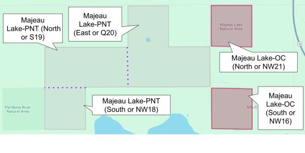
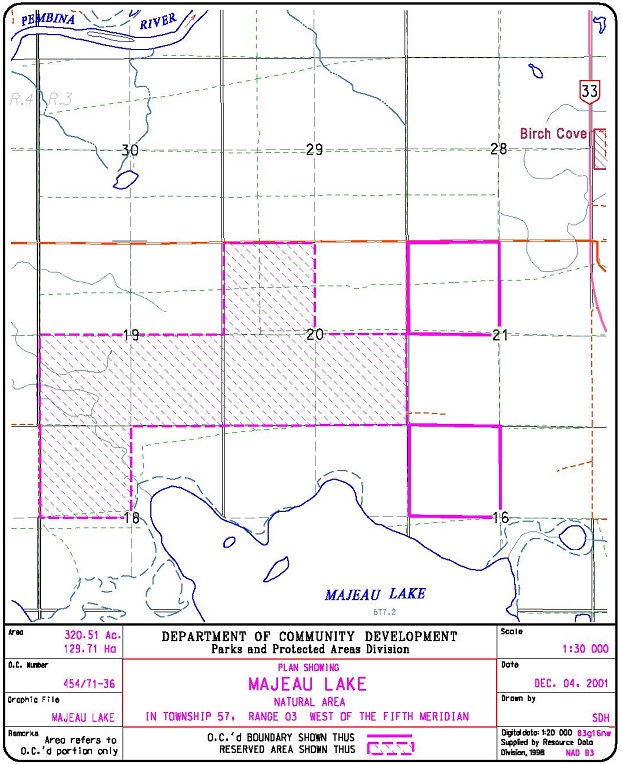
This Natural Area is composed of three distinct land parcels: one large PNT portion (six quarter-sections) and two smaller OC portions, each one quarter-section in size. All parcels are north of, but not on, Majeau Lake.

Map of the Area
Any maps and map views are for general information only. Do not rely on them for navigation or to determine legal boundaries.
Parcel Descriptions
The following parcel descriptions are used when visiting or describing this site. These names are unofficial.
Other Information
Majeau Lake Natural Area has slightly undulating topography with upland aspen-balsam poplar forest, black spruce/Labrador tea peatland, willow shrubland (along the stream), and an old open field that is reverting to shrubland and aspen forest.
Limited disturbance was observed during a visit at Christmas 2020 in both the north and south portions of the site. Range Road 34, at the western boundary, has limited maintenance in the winter, so an appropriate vehicle is advised. This road stops roughly at the northwest corner of the southern quarter. Primitive trails exist particularly along the western fence line including an abandoned cut line. Numerous animal tracks were observed with negligible human activity [1].

No Access to the Lake from the southern OC portion. The intermediate land appears to be Crown Land with a grazing lease provided to a local farmer [2].
The Majeau Family, for whom the lake was named, were settlers from Montreal. They were well known for their hospitality and were often visited by travelers in the area. Prior to this name, the lake was called Island Lake [3].
Biophysical Observations (via iNaturalist)
Are you a member of iNaturalist.ca? It is free to join and you can help nature by making observations with your smart phone.
If there are no or only a few observations, how about visiting and adding some? While there, complete a site inspection report (but read the Site Inspections terms and conditions first).
Observations & Projects for this Natural Area
- Majeau Lake Complex Observations.
- Majeau Lake OC.
- Majeau Lake (PNT).
- No iNaturalist Projects.
Site Statistics
| Site Name | Majeau Lake |
| Site Type | Natural Area |
| Subtype | Order-in-council (OC) |
| Natural Region(s) | Dry Mixedwood |
| O.C. No. (Land Ref. Manual) | 454/71 |
| PASite ID (Map Ref #) | 272 |
| Site # (Parks Website) | 546 |
| Total Area | 129.71 ha. (320.51 ac.) |
| Steward-Status | |
| Recreation Activities | none noted |
| IUCN | NA |
| Operated By | Parks Division |
| Notes and Comments |
| Site Name | Majeau Lake (PNT) |
| Site Type | Natural Area |
| Subtype | Protective Notation (PNT) |
| Natural Region(s) | Dry Mixedwood |
| O.C. No. (Land Ref. Manual) | N/A |
| PASite ID (Map Ref #) | 272 |
| Site # (Parks Website) | N/A |
| Total Area | 383.64 ha. (948.00 ac.) |
| Steward-Status | |
| Recreation Activities | |
| IUCN | |
| Operated By | |
| Notes and Comments |
References
The following links are provided as a courtesy but are not verified or endorsed by SAPAA. Clicking on the link will cause you to leave the SAPAA website. Primary source of information is: Information & Facilities – Majeau Lake Natural Area | Alberta Parks (All links accessed on 2026-02-04).
- Unpublished site report, December 29, 2020; F.Potter.
- Lac Ste. Anne County Map
- Aubrey, Merrily K., ed. Concise Place Names of Alberta. Calgary: University of Calgary Press, 2006, p. 200.

Majeau Lake (OC), 2020-12-29 F.Potter 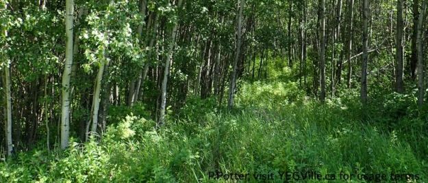
Overgrown track heading East from RR 34, Majeau Lake NA (North-OC), 2025-07-03, P. Potter. 
Looking East into the SW corner of the site from RR 34, Majeau Lake NA (North-OC), 2025-07-03, P. Potter. 
Looking SE into a large clearing, possibly where the gas pipeline right away branches, Majeau Lake NA (North-OC), 2025-07-03, P. Potter. 
Looking West from the pipeline corridor at an overgrown track heading West into the site, Majeau Lake NA (North-OC), 2025-07-03, P. Potter. 
Surveyors tape suggests an attempt to extend the ATV track in the area, Majeau Lake NA (North-OC), 2025-07-03, P. Potter. 
Giant Red Paintbrush (Castilleja miniata), Majeau Lake NA (North-OC), 2025-07-03, P. Potter. 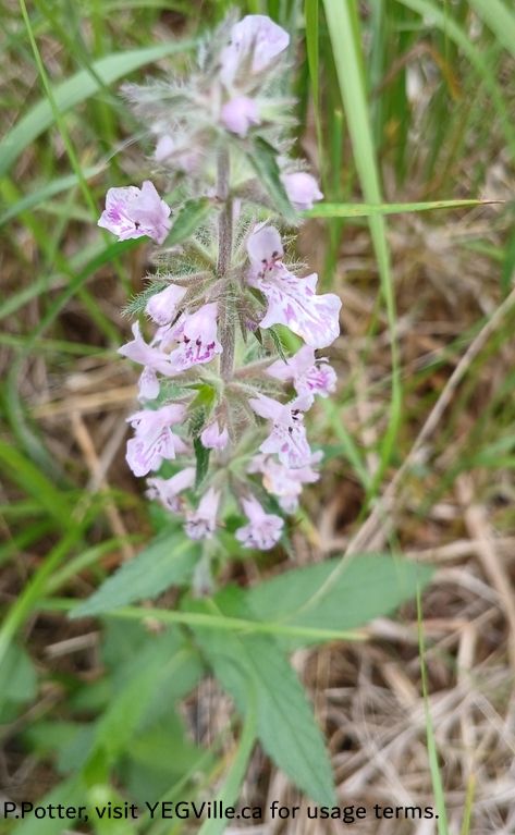
Prairie Woundwort (Stachys pilos), Majeau Lake NA (North-OC), 2025-07-03, P. Potter. 
Spreading Dogbane (Apocynum androsaemifolium), Majeau Lake NA (North-OC), 2025-07-03, P. Potter. 
Veiny Pea (Lathyrus venosus), Majeau Lake NA (North-OC), 2025-07-03, P. Potter. 
A cocoon created by a spittlebug nymph. They excrete a substance from their anus, along with air, which creates this protective covering; Genus Philaenus, Majeau Lake NA (North-OC), 2025-07-03, P. Potter.
