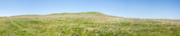
Located about 10 km west of the town of Milk River, this large Heritage Rangeland Natural Area protects one of the few remaining areas of native grassland in Alberta. The terms Heritage Rangeland and Natural Area are applied interchangeably to this site as this distinction has not been resolved by the Provincial Government.
Map of the Area
Any maps and map views are for general information only. Do not rely on them for navigation or to determine legal boundaries.
Other Information
This NA contains dense nesting bird-of-prey populations including Ferruginous Hawks, Golden Eagles and Prairie Falcons. Rare Yellow-bellied Marmot and Northern Leopard Frogs inhabit the site and rare fishes including Mottled Sculpin, Stonecat and Finescale Dace are found in the rivers. Rare plants in the area include spiny milk-vetch, fine-leaved hymenopappus and creeping draba.
In addition to its biodiversity this area protects important springs and wetlands as well as significant historical resources (tipi rings and medicine wheels).
This site lies in the Grassland Natural Region, Mixedgrass and Foothills Fescue Sub-regions. Preserving such natural areas has been difficult as they occur in some of the best agricultural land in Alberta; the challenge has been to find representative landscapes that have not been cultivated.
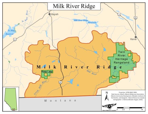
AWA Area of Concern. Ross Lake Natural Area and this NA both fall within a larger Alberta Wilderness Association Area of Concern, the Milk River Ridge. Framed by two rivers, the Milk and St. Mary’s, this area is a stronghold for Alberta’s native grasslands. The area houses many rare and endangered fish, amphibians, birds and plants [1].
Water and Borders. The Milk River is susceptible to drought as it relies heavily on spring runoff for its natural flow. Its low flows have been a source of contention for Southern Alberta’s agricultural producers, as many have advocated for damming or diversion to increase the flows. Damming could result in negative environmental impacts to the riparian habitat surrounding the Milk River [1].
Under various treaties, the waters from both the St. Mary and Milk Rivers are apportioned to irrigation at different rates [1].
2018 Proposed Expansion Fails to change the designation from a NA to a HR and increase the size by 3,173 hectares. Despite public support, the expansion and re-designation has not been enacted [1].
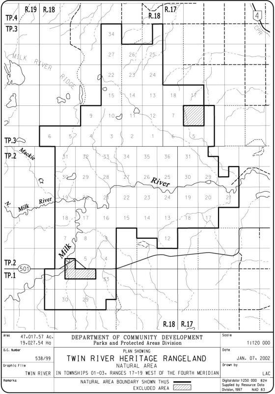
Enclaves, Privately Owned. Within the NA are two one-section-sized areas excluded from the site and in private ownership according to the county landownership map [2].
HR or NA or Both? Protected Areas have specific classifications two of which are ‘Heritage Rangeland’ and ‘Natural Area’. So which of these two applies to this site? The answer is both and in limbo. Along with six other sites it was given the NA designation in the late 1990s during the Special Places 2000 program. The rationale was that this was the ‘best fit’ for interim management until the legislation for the Heritage Rangeland class was proclaimed. Management of these sites is a hybrid between a NA and HR until legislation is in place [3].
Site Statistics
| Site Name | Twin River Heritage Rangeland |
| Site Type | Natural Area |
| Subtype | Order-in-council (OC) |
| Natural Region(s) | Foothills Fescue; Mixedgrass |
| O.C. No. (Land Ref. Manual) | 538/99 |
| PASite ID (Map Ref #) | 586 |
| Site # (Parks Website) | 508 |
| Total Area | 19027.54 ha. (47017.57 ac.) |
| Steward-Status | |
| Recreation Activities | none noted |
| IUCN | VI |
| Operated By | Parks Division |
| Notes and Comments |
References
The following links are provided as a courtesy but are not verified or endorsed by SAPAA. Clicking on the link will cause you to leave the SAPAA website. Primary source of information is: Information & Facilities – Twin River Heritage Rangeland Natural Area | Alberta Parks (All links accessed on 2025-10-23).
- Alberta Wilderness Association, Area of Concern, Milk River Ridge.
- County of Warner, Mapping
- Government of Alberta, Fact Sheet, “Heritage Rangeland” natural areas.
